
Based in the City of Brookings, South Dakota, Brookings Municipal Utilities (BMU) supplies power to approximately 12,000 customers. It also manages water and wastewater utility services, internet and telecommunications for Brookings. While the company had a successful track record using AutoCAD to manage electric utility operations, its leadership recognized the need to modernize operations. BMU worked with a Denver, Colo-based location and mapping technology company to replace its legacy mapping with an enterprise GIS that integrates disparate data sets, delivers powerful analysis capabilities, and provides a foundation for the utility's future. In this Q&A, Alex Shimmel, who represents the mapping technology company, and Russ Halgerson, who is the is the electric department manager at BMU, discuss their collaboration on modernization and share insights for other utilities.
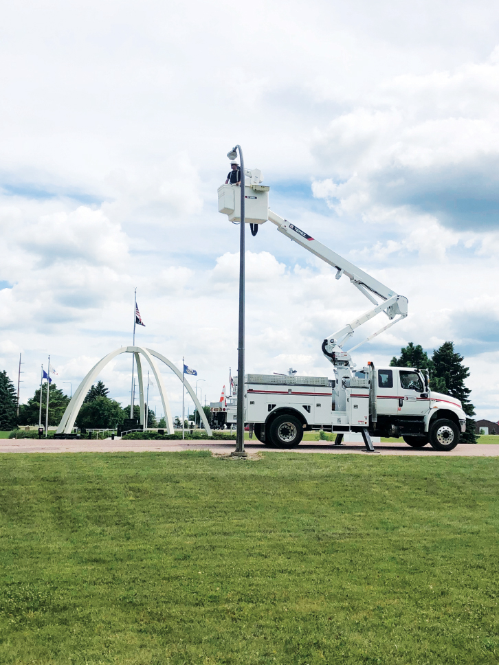
Image credit: Locana
Shimmel: BMU’s GIS modernization initiative is a great case study for other utilities that are looking to migrate from legacy systems to a modern GIS system. Can you give readers some background about where things stood before this project?
Halgerson: This is a timely topic for our industry because so many utilities are running up against the significant limitations of legacy systems that have served them well for a long time. This topic comes up nearly every time I talk to my peers at other utilities.
Shimmel: How long was your legacy system in place?
Halgerson: Decades, which is a great thing. We used AutoCAD as the foundation of our mapping systems, and it met our needs for a very long time. As you know, IT technologies come and go, and it’s very rare for one to have staying power like that. For decades, AutoCAD was a reliable backbone for the mapping processes and location information that is so critical to our operations. But during the last few years of its service to us, its limitations became more and more of an issue for our daily operations. One of the biggest issues we wanted to address was how siloed our information databases had gotten. After decades of use at the departmental level, those databases had become more and more isolated from one another. And as a result, critical data was often stranded on disconnected islands of information.
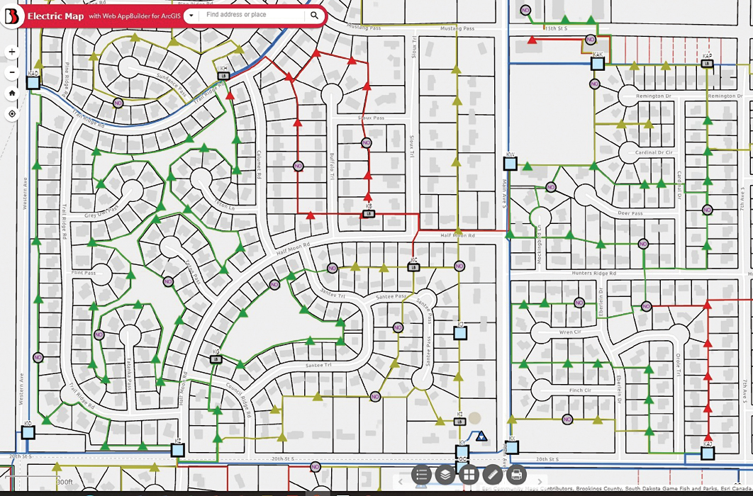
Image credit: Locana
Shimmel: That is one of the biggest pain points I hear when I start talking to utilities about their legacy systems. Having siloed data causes so many operational headaches.
Halgerson: Exactly. It was causing inefficiencies that became harder and harder to overlook. Plus there was a growing opportunity cost as well. There were a lot of things we wanted to do that we couldn’t because of those data problems and because of that disconnectedness. We knew that huge efficiencies and benefits would come from breaking down those silos. It simply wasn’t possible to do that while staying with those legacy systems. It’s a difficult decision when an organization has used a legacy system for so long, but we knew we had to make a change.
Shimmel: Can you talk more about the decision to modernize? Back during that decision process, what was your team most excited about accomplishing by breaking down those silos?
Halgerson: We knew there would be a long list of benefits, but the thing that came up again and again in our meetings was decision-making. We wanted to make faster, better decisions at every level of the organization, and a more modern GIS system would be a huge catalyst for that. By unifying our data on a more modern GIS platform, decisionmakers would be able to make faster decisions with the help of data-driven insights at their fingertips. Better, faster decision making would mean more efficient processes, better collaboration across the organization, and better service for our customers.
Shimmel: I’m so glad you talked about that because it’s the biggest thing I hear from people I talk to after they modernize their GIS. It removes roadblocks and inefficiencies that they accepted as an unchangeable part of their workflow every day. Plus it removes impediments that they didn’t even realize were holding back their processes.
Halgerson: That was definitely our experience. We knew it would be a gamechanger for key departments like our GIS team, but it didn’t stop there. We saw similar benefits across the organization, and at every level — from our leadership team all the way to our mobile workers that are doing work in the community.
Image credit: Locana
Shimmel: Let’s talk about the platform you chose.
Halgerson: Sure. After looking closely at all the major platforms, we decided that a next generation utility network platform was the right fit for us. Your team was very helpful as we evaluated the different options and made that decision. It was great to have a partner that was neutral like Switzerland during the process, since you have experience working with all the vendors. One of our key buying criteria was analytics. We wanted to be able to empower our teams with data-driven insights that they can put to use every day. That was big for us. So was ease of implementation and ease of use. Many utilities are much larger than us and have more resources for complex implementations and steep learning curves. But that’s not us. It was critical for us that we could get it up and running successfully and have our team feel very comfortable using it right away.
Shimmel: What advice do you have for other utilities going through a similar selection process?
Halgerson: I get asked that quite frequently, and I always emphasize how important it is to have the right implementation strategy. For something like a GIS system that impacts every part of a utility’s operations, it’s important to have a streamlined implementation strategy that puts people first. Yes, this is a technology migration, but it’s the people who will be using it every day that need to be kept front and center. Your team was a big help with that, given how many other Esri UN implementations you have done.
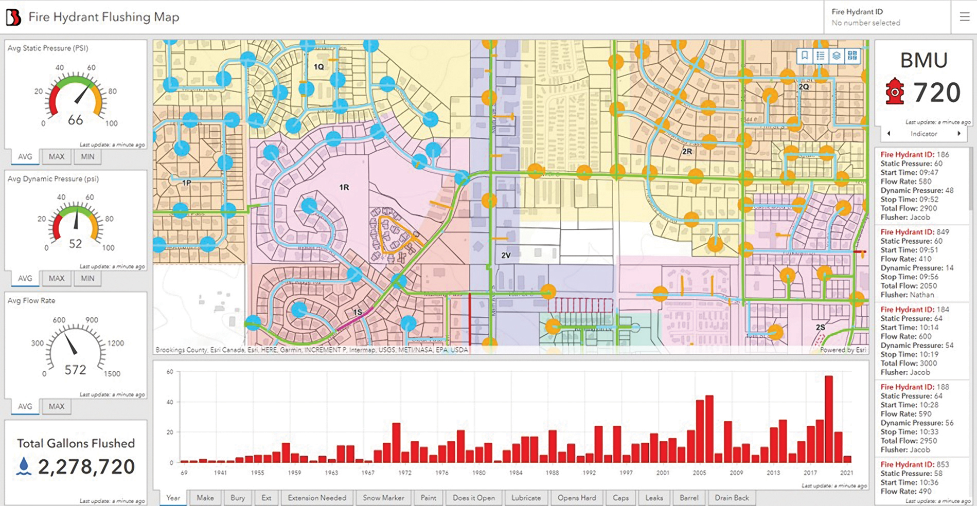
Image credit: Locana
Shimmel: Change management is so important. The BMU team made that a guiding principle for this GIS modernization initiative, and it really paid off.
Halgerson: Another thing that I always mention to peers at other utilities is the importance of how you prepare your data. You have to get your data right in order for the platform rollout to truly live up to expectations.
We worked hard on that early in the process by assessing each of those islands of data, cleaning it, preparing it for use in a next generation platform for utility management, and then having a great strategy for the data migration process.
Shimmel: That is critical to focus on early in the process when going from legacy systems to a moderm utility network platform. Organizations are often stunned at how many batches of disconnected data they have across those legacy systems once they start doing a full inventory ahead of migration. And after years or decades in disparate GIS systems, the data sets often need a lot of TLC before they can be migrated.
Halgerson: Doing that up-front work to get our data right was a key factor in the success of our implementation. You and I started talking about the importance of that very early on, and I strongly suggest that approach to other utilities considering this kind of upgrade.
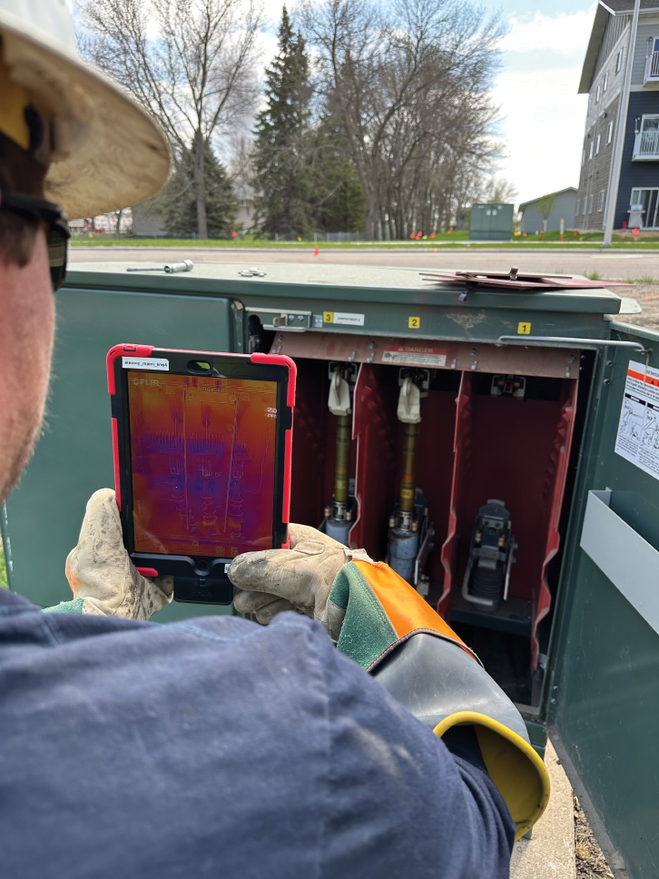
Image credit: Locana
Shimmel: Let’s talk about the platform implementation. BMU deployed a utility network as the centerpiece of this initiative. Why was that the right choice for BMU?
Halgerson: Yes, we deployed the utility network platform and went with a package that allows for editing, visualizing and analyzing spatial data. This enabled us to get so much more out of our data.
Shimmel: Your models were previously only 2D, right?
Halgerson: Yes, only 2D. This was a huge upgrade for us, giving our team network-centric, 3D models that have far greater detail and accuracy. The richness of the data is a huge asset. A great example of this involves our switchgear. Before this implementation, mapping that part of our infrastructure was time-consuming and complex, but ArcGIS makes it far simpler and gave us far better information. By using templates for the inventory of switchgear that BMU uses in our network, we can rapidly add that information to our GIS system with a level of accuracy and detail that was impossible before. That is one of many ways that this initiative has made our digital GIS models a far better representation of the real-world network.
Shimmel: The last time we talked, you gave me an update about how this is helping with customer service, too. That’s not necessarily what immediately comes to mind when someone thinks about GIS and utilities, but there’s a very positive impact there, right?
Halgerson: We pride ourselves on the level of service we give to our customers, and communication is so important for that, particularly during outages. No one likes outages, but they happen. The key is identifying and responding to them quickly and keeping customers updated so they aren’t in the dark, both literally and figuratively. With this GIS platform, our team is able to not only identify outages faster but also quickly determine exactly how many customers will be affected downline from the faulty equipment. Our team can then take rapid action to notify customers and keep them apprised of how quickly service will be restored. That kind of notification process was very complex to coordinate in the past. Now, our team has far more information and can take action quickly to support our customers.
Shimmel: That stood out to me when you shared it because it shows how wide-reaching the impact is on a utility’s operations.
Halgerson: Totally agree. It has had a positive impact on so many aspects of our operations. That is what makes this intimidating for so many organizations, though. Those decades-old legacy systems have been serving so long and have deep, deep roots across so many departments and so many day-to-day processes. It’s natural to worry about making a change and feel a sense of inertia. But this initiative has unlocked so much for our organization, and I think we’ve only started scratching the surface of what we can do for our customers with this foundation in place.

Russell Halgerson is the electric department manager at Brookings Municipal Utilities. Halgerson received his Bachelor’s degree in electrical engineering from South Dakota State University in 2007 and is a licensed professional engineer in South Dakota and Minnesota. He has more than 15 years of electric utility experience in both distribution and transmission, including engineering planning, design, project management and operations.
![]()
Alex Shimmel is a GIS consultant at Locana. In this role, he works with gas and electric utilities to conduct successful implementations of advanced geospatial solutions. He earned his degree from Tufts University.