
Jeff Armstrong, Senior Vice President of Indianapolis, IN-based Analytical Surveys, Inc. (ASI) oversees the company’s cadastral mapping services and says most local government landbases today use digital imagery (orthophotography) with basic right-of-way and property line information to provide a primary base map layer for GIS applications. Additional layers describing zoning, land use , emergency management zones and so on can be digitized, and along with planimetric data, can then be superimposed or overlaid on the orthophotography layer. (Planimetric refers to data that is generated from aerial photography and can include manmade, and natural features such as streams, roads, edges of pavement, building footprints, manholes and poles.)
Armstrong notes that all GIS landbases are created to show the location (per longitude and latitude) of features on the surface of the earth. Many existing land bases have been created to different degrees of spatial accuracy, depending on the precision of the source data and the map’s intended use. In the United States, most GIS landbases tie their accuracy to the United States Geological Survey (USGS) Universal Transverse Mercator (UTM) grid system for regional zones of the country. Or within a single state, the state plane coordinate system as defined by the USGS is used.
Data accuracy can vary greatly from one landbase to another and the degree of accuracy is generally driven by the planned uses of the landbase data. For example, local governments generally put much of their GIS budget and efforts into developing and maintaining highly accurate landbases which can be used for tax assessment, engineering, and planning purposes. Often, these local government landbases are created at “sub-meter” accuracy, which means the data’s position on the surface of the earth is mapped accurately to +/-1 meter or better. By comparison, gas and electric companies are usually satisfied with +/-10 up to even +/-40 foot accuracy. Landbase accuracy adheres to the axiom of the higher the accuracy, the higher the price, so electric and other energy companies usually opt to invest in the facilities piece rather than the landbase piece of the GIS. A utility or energy services company, Armstrong points out, typically uses the landbase for general reference purposes such as determining whether a transformer is located on the left or right side of a street. “For precise locations,” Armstrong notes, “the company will send out a location crew anyway” which makes a highly accurate and thus expensive landbase unnecessary for the typical electric GIS. Armstrong says “it’s important to remember that in the end, the landbase will only be as accurate as it was in the beginning” when it was being developed according to specifications.
According to Phil Worrall, ASI Director of GIS Data Distribution, “Landbase accuracy issues also become a key factor for multi-participant or shared GIS initiatives. The multi-participant approach means that each of the participants such as the county and city governments, water utility and local electric and gas service providers all contribute to building a shared landbase upon which they can build their own data layers. As a result, the GIS landbase might reflect a wide range of data accuracies. Armstrong points out that while a shared GIS appears to be a cost cutting strategy for acquiring a landbase, “what might suit the needs of an electric company might not be accurate enough for a county government.” Before embarking on the development of a landbase, Armstrong recommends enlisting a geospatial data management consultant to help establish current as well as future needs as they relate to landbase accuracy.
In terms of acquiring landbase data, the maturity of “off-the-shelf ” government and third-party data products and also the availability of this data over the Internet means up-to-date landbase data is now readily available, often at a reasonable price. Worrall says that “off-the-Web landbase products are still complex databases and far from being plug-and-play products.” He recommends enlisting some outside expert assistance to help with product evaluation, selection and installation. A consultant can also determine the compatibility of the landbase data with the GIS. Worrall says that another factor to consider is vintage of the data. He recommends checking on the product’s update schedule and the cost and ease of purchasing and installing these data updates. The World Wide Web today has a wealth of geospatial data available, however finding and securing the best data to specifically support an organization’s GIS requires more skill than that of the casual or an outside expert here as well, specifically a consultant who is highly skilled and experienced in GIS landbases and Web data mining. This approach will save time and ensure that the best and most appropriate landbase data is acquired. Another GIS issue that confronts energy companies involves the acquisition and merger of previously independent operating companies each of which has its own existing maps and often a GIS. However, even with various platforms and formats of data, Worrall says, many GIS data viewing solutions like ASI’s web-based data distribution service allow GIS data to be accessed via the Web in a single homogenous view regardless of the software platform used by each component GIS. In addition, the web-based viewing tool eliminates the need for data translation. “This type of solution allows utility and energy companies that are facing the task of merging several disparate information systems to postpone their GIS migration decision yet get the full benefit of access to all the GIS data assets during the interim.” Worrall explains that, “a first easy step is to put the entire service territory landbase for the new company into a single view to provide immediate value to the entire organization. Then, the same approach can be applied to the facilities data.”
Metadata — Crucial Factor in Effective Landbase GIS Data Management
When a landbase is derived from many different sources, metadata (data about data, such as source, accuracy, currency, etc.) becomes a key factor for its successful use and management. Metadata is also crucial to effectively managing and maximizing the use and value of geospatial data. Worrall notes, “Metadata is particularly important when GIS data comes from a number of different sources and being shared with outside parties." The United States government has defined and documented metadata standards which are very helpful in making the most of metadata.
The U.S. Federal Geographic Data Committee (FGDC) coordinates the development of the National Spatial Data Infrastructure (NSDI). The NSDI encompasses policies, standards, and procedures for organizations to cooperatively produce and share geographic data. The 17 federal agencies that make up the FGDC are developing the NSDI in cooperation with organizations from state, local and tribal governments, the academic community, and the private sector. The FGDC promotes the development, maintenance, and management of distributed databases of geospatial data that are national in scope and has adopted the Content Standard for Digital Geospatial Metadata for labeling geospatial datasets. This standard provides a common set of terminology and definitions for the documentation of geospatial data, including data elements. The standard specifies the following metadata:
Identification Information - basic information about the data set. Examples include title, geographic area covered, currentness, and rules for acquiring or using the data.
Data Quality Information - an assessment of the quality of the data set. Examples include positional and attribute accuracy, completeness, consistency, sources of information, and methods used to produce the data.
Spatial Data Organization Information - the mechanism used to represent spatial information in the data set. Examples include the method used to represent spatial positions directly (such as raster or vector) and indirectly (such as street addresses or county codes) and the number of spatial objects in the data set.
Spatial Reference Information - description of the reference frame for, and means of encoding, coordinates in the data set. Examples include the name of and parameters for map projections or grid coordinate systems, horizontal and vertical datums, and the coordinate system resolution.
Entity and Attribute Information - information about the content of the data set, including the entity types and their attributes and the domains from which attribute values may be assigned. Examples include the names and definitions of features, attributes, and attribute values.
Distribution Information - information about obtaining the data set. Examples include a contact for the distributor, available formats, information about how to obtain datasets online or on physical media (such as cartridge tape or CD-ROM), and fees for the data.
Metadata Reference Information - information on the currentness of the metadata information and the responsible party.
See the following web sites for more information:
- Open GIS Consortium (http://opengis.org),
- Federal Geographic Data Committee (FGDC) (http://fgdc.er.usgs.gov/) and
- Content Standard for Digital Geospatial Metadata:
(http://fgdc.er.usgs.gov/metadata/metadata.html)
The Center for Advanced Spatial Technologies (CAST) lists a “Guide to mostly online and mostly free U.S. geospatial and attribute data”
(http://www.cast.uark.edu/local/hunt/#BASE).
With advances in technology that allow GIS and landbase data to be maintained through a variety of innovative strategies including remote, as well as onsite outsourced solutions, maintenance has become another important value area for landbase management. Once a landbase is created, the number one issue is maintenance says Armstrong, which makes the development of a plan and budget for ongoing maintenance of the landbase essential. He says organizations with GIS landbases are “not only asking how do you maintain it, but as importantly, how much will it cost and how much should I budget for maintenance in years to come.” A lack of planning for the future is a major pitfall of GIS data management, Armstrong notes, which makes the development of a plan and budget for ongoing maintenance of the landbase essential.
With the advent of T-1 communications lines and other technology tools, maintenance programs can be easily outsourced and then data and systems can be maintained remotely or by outsourced personnel who work onsite. An outsourced maintenance strategy alleviates an organization of the burden of keeping in-house staff trained, updating software, purchasing additional hardware and performing maintenance tasks.
Landbase Acquisition – Rules of Thumb
- Enlist an expert consultant to guide and plan the landbase acquisition, as well as maintenance program. The consultant should have substantial experience in GIS needs analysis and also with technical data management issues such as data mining and metadata development.
- For data acquisition, explore the availability and also suitability of existing data as packaged off-the-shelf products, as well as Internet sources including county and state governments and data clearinghouses.
- Leverage additional value from the landbase by pursuing distribution strategies such as distribution using universal web viewing tools.
- Adopt a metadata program for sound management of landbase data.
- Understand up front projected needs and associated data accuracy requirements. (A word of caution -- with accuracy, there’s a common misconception that the higher the accuracy, the better the data. Accuracy should fit needs as the number one criteria.)
- Don’t bank on being able to remarket your land base to make money or even to recoup costs.
- With off-the-shelf products, check the update schedule, data currency or vintage, and compatibility to current software and data so a landbase maintenance program can be planned to coincide with product updates and updates to the GIS software.
- Make sure there’s a process in place that allows easy integration of the landbase into the GIS.
- Plan to keep out of the landbase maintenance business by tapping outsourcing strategies.
Autodesk® and Autodesk MapGuide® are registered trademarks of Autodesk, Inc.
Peggy Sailors is a communications specialist with Indianapolis. IN-based Analytical Surveys, Inc. (ASI) and can be reached at psailors@anlt.com. ASI specializes in advanced geospatial data management solutions and cadastral mapping, providing a full range of services to customers in the energy and utility industries. ASI can be reached on the World Wide Web at www.anlt.com.
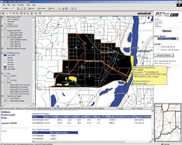
Figure 1: Off-the Shelf U.S. Government Raster Land Base Data Example: One-meter DOQQ digital imagery from the United States Geological Survey (USGS) is displayed in the background and is overlaid by a transparent USGS raster Quad map and flood zone areas from Federal Emergency Management Association (FEMA).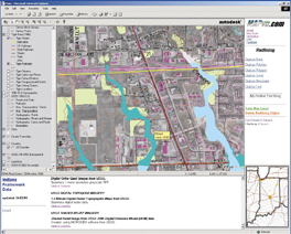
Figure 2: Off-the-Shelf U.S. Government Vector Landbase Data Example: United States Geological Survey USGS-Digital Line Graph Land and Boundary Features, U.S.-Census Bureau-Topologically Integrated Geographic Encoding and Referencing System (TIGER) Streets, Census Tracts and Demographic Data, U.S. Fish and Wildlife Service - National Wetlands Inventory Survey, NOAANational Geodetic Survey Monuments, Natural Resource Conservation Service-SSURGO Digital Soil Survey, Federal Emergency Management Association (FEMA)-Flood Zone Boundaries.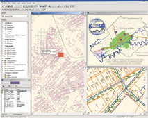
Figure 3: A Homogeneous GIS Data Viewing Application (ids™) for Knox County Tennessee, City of Knoxville, and the Knoxville Gas, Water, Electric, and Sewer Utility Boards. (Source GIS data from Intergraph, Bentley, ESRI, MapInfo, and MrSID databases.)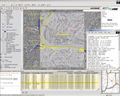
Figure 4: Metadata Report-United States Geological Survey (USGS) Digital Orthophoto Quarter Quad (DOQQ).