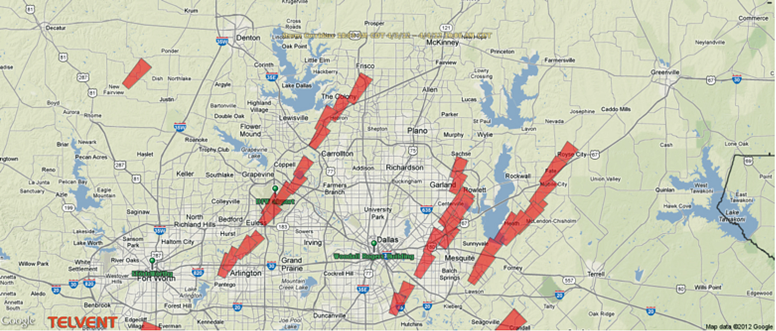
In Texas, the question isn’t if severe weather will hit, but when – so utility companies need to be on the alert for the formation of severe weather and preparing for potential outages. In April of 2012, Texans were hit by an outbreak of tornadoes in the Dallas-Fort Worth metropolitan area. A low pressure system started tracking across the Southern Plains on April 3, and what was initially believed to be a wind and hail event developed quickly into a tornado outbreak over a heavily populated urban area. Twenty-two tornadoes formed that day, including an EF3 rated tornado in Forney, Texas that devastated a subdivision and a school. An estimated 1,100 homes were damaged and at least 349 were destroyed. Remarkably, no one was killed and few injuries were reported.
Oncor, the largest electric distribution and transmission system in Texas, found itself in the midst of a major weather event with outages impacting customers across their service area. With more than three million residential and commercial customers and approximately 118,000 miles of distribution and transmission lines throughout central Texas, Oncor was heavily impacted by the tornado outbreak. From April 3 to April 4, Oncor’s power grid suffered more than 1,500 interruptions, affecting nearly 150,000 customers. The peak outage occurred on the afternoon of April 3, affecting more than 40,000 customers. The longest outage was one day, four hours and 23 minutes, with 26 million customer minutes of interruptions. Overall, there were 82 feeder outages, 472 fuse outages, 47 recloser outages, 609 transformer outages, 25 switch outages and 385 service outages.
The utility needed to restore power to affected customers as quickly as possible while keeping an eye on crew safety as storms still racked the area. Accurate and up-to-date weather forecasts were a key method for Oncor to help maintain system reliability as well as protect its crews as they brought back power to its customers. The utility relied on Telvent’s MxVision WeatherSentry® Online Utility Edition to mitigate and respond to the April storms and other severe weather risks. The advanced, web-based weather information platform helps anticipate potential outages due to severe weather and lightning strikes to reduce service interruptions, and better schedule and protect crews. The subscription-based service provides comprehensive real-time weather data that’s tailored specifically to the needs of utilities. Enhanced radar and alerting capabilities that include real-time information allow utilities to monitor weather for a specific location.
“Oncor uses Telvent’s MxVision WeatherSentry to monitor current weather and geographical information,” says Oncor Business Continuity Consultant Kyle Stuckly. “This information allows our operating centers to request additional personnel during severe weather events to maintain quality service and ensure proper response time.” Crews are ready and in place to respond to the aftermath of severe weather and restore power to customers as quickly as possible. Detailed weather and geographical information allow Oncor to make decisions about which service areas are now clear of major weather events and are safe for crews to undertake repairs.
Tornado outbreaks like the one in April of 2012 are an ongoing threat faced by utilities operating in Texas. Severe thunderstorms can occur in Texas in just about any month, but the greatest number of severe storms is seen from March through June. The summer months see severe weather spawning from hurricanes and tropical storms from June through November, with increases in the fall due to more potent cold fronts.

April 2012 Texas Storm Track
(click to enlarge)
For Oncor, lightning is the number one cause of power outages. Using Telvent’s real-time lightning feature and radar imaging, Stuckly says, “Oncor is able to improve its ability to safely respond to storm outages and improves customer relations by more accurately projecting estimated times of restoration. Estimated times allow Oncor customers the ability to safely await restoration during extreme conditions or extended service interruptions.”
Real-time lightning detection is based on a continual feed of lightning strike data from the Vaisala North American Lightning Detection Network (NALDN®). NALDN sensors measure high and low frequencies of cloud-to-cloud and cloud-to-ground lightning strikes. The proprietary technology uses GPS time-of-arrival and magnetic direction from true north to optimize detection and location of events. Vaisala’s Network Control Center ingests the raw data and calculates strike positions and related data such as strike amplitude and polarity, which is then transmitted to MxVision WeatherSentry Online. Oncor can then see the lightning detection displayed along with weather radar, which gives them a good sense of whether or not a line of storms is approaching. By basing lightning predictions on actual lightning presence, Oncor doesn’t deal with false alarms and has a highly accurate view of what is being impacted.
Through its advanced weather service, Oncor is able to select weather data that is most important to its operations, like thunderstorms, which get displayed on one centralized weather map.
The location-specific forecasts, which can range from an entire region down to individual roadways, allow Oncor to closely monitor assets, transmission lines, and boundaries. Conditions are anticipated up to 15 days out, with hourly outlooks for the first three days. Forecasts are updated hourly with the best, most current weather forecasts. Wind speed, chance of precipitation, and more can be viewed as graphs, radar images, or on high-resolution street level maps to provide the ultimate view of operational conditions.
MxVision WeatherSentry’s high-resolution street level maps display color-coded storm corridors, winds and lightning for a complete view of approaching storms, telling utilities at a glance what conditions are associated with each storm (like large hail or tornadoes). The tracking system shows where severe weather is, where it is heading over the next thirty minutes and what time it will reach locations in its path.
To best prepare for severe weather, utilities need to know what will most likely happen based on current weather conditions at exact locations, so it can be ready for potential outages. Real-time decision making is facilitated by customized weather alerts. These alerts are set-up to notify Oncor when predetermined thresholds have been met; helping utilities best position their crews. An example would be Oncor monitoring a newly formed storm in its service area. The storm may start off with light rain and wind gusts but if it intensifies, an alert will inform staff that it’s no longer safe to work. At this time, managers can get crews to safety while also making the necessary preparations to quickly begin restoration efforts after the storm passes.
Mobile weather apps allow Oncor crews to stay on top of changing weather conditions whether in the office or out in the field. Roaming weather information and customized notifications are delivered instantly using the phone’s GPS location. Meteorologists are available to Oncor 24/7 for consultations online from computers and mobile devices. The energy provider also has access to questions and answers posted by users across the country, as well as twice-daily forecasts tailored to their region.
Stuckly says, “Through the use of Telvent’s weather data, Oncor is able to improve its ability to safely respond to storm outages and improves customer relations by more accurately projecting estimated times of restoration.” Oncor and utilities large and small across the country rely on quality weather solutions to save dollars, improve outage response time and, most importantly, keep crews and customers safe during severe weather events.
About the Authors
 Jeff Johnson is the Chief Science Officer for Telvent DTN. Johnson graduated with a Bachelor of Science degree in meteorology from the University of Wisconsin in Madison. He became an American Meteorological Society Certified Consulting Meteorologist in 1993. His experience in meteorology comes from over 30 years of weather forecasting for various industries including Energy, Aviation and Transportation. Johnson focuses on medium and long range weather forecasts for Telvent DTN. Contact Telvent at 800.610.0777
 Kyle Stuckly (Kyle.Stuckly@oncor.com) is a Business Continuity Consultant at Oncor and a registered Professional Engineer in Texas. He is responsible for Emergency Preparedness Plans such as Emergency Restoration, System Emergency Operations, Network Emergency, and Black Start. Additionally, he maintains Oncor’s System Operation Center in Dallas, Texas. Kyle has 20 years with Oncor in Distribution Design, Distribution Operations Center support, and his current role since January 2007.


