Approximately seven million miles of transmission and distribution lines stretch across the U.S. which, for the most part, are decades old. In the West, the pressure is immense for utilities to keep the power flowing without contributing to wildfires. This year marks one of the worst wildfire seasons in history. By halfway through the year, a total of 6,540 fires had been recorded in California, burning over 1,161,027 acres (405,000 ha) across the state. Colorado, Idaho and Montana also suffered from unprecedented wildfires. High heat, droughts and winds were a significant factor and wreaked havoc for utilities to properly maintain their lines and transmission structures – especially in the backcountry. Given the abundance of forests and deep canyons in these states, assuring that transmission towers and power lines are properly maintained and cleared of vegetation is a vital program for utilities.

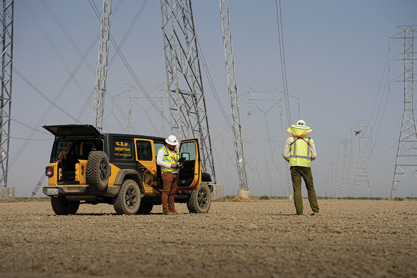
Figure 1: Cyberhawk field team preparing to perform a routine integrity inspection.
Taking to the skies
Traditionally, utilities have deployed teams of ground crews and helicopters to inspect and repair transmission structures, lines and associated equipment. These inspection methods are time-intensive, limited in their capabilities and often dangerous, requiring linemen to work at height and/or trudge through thick brush or deep mud for miles. Because of these limitations, it can be difficult for utilities to meet the National Grid requirement to patrol every fault within seven days. Helicopter surveys can be faster but are frequently unable to capture detailed images of specific critical areas of a transmission structure due to obstructions or inclement weather.
For the most part, utilities are still reactive, responding to maintenance issues as problems arise or customers report concerns. With aging assets and the increased frequency of severe weather events, soon this will no longer be acceptable.
Fortunately, rapid advances in Unmanned Aircraft Systems (UAS) or drones, along with digital image capturing software and cloud storage, make it possible to be proactive and identify maintenance needs safely before they cause problems.
While drone-based inspections (Figure 1) are new to the utility industry, they are proving to be a critical asset in utilities' outage and fire mitigation programs. By quickly inspecting conductor clamps, insulator fittings, cotter pins and other integral infrastructure components for defects, repairs can be prioritized and carried out quickly. For critical issues, the repair can happen within 24 hours. With digital eyes in the sky, pilots can see other hazards such as encroaching vegetation, dangerous campfires and other issues that pose threats to people and the grid.
Experience makes the difference
Some utilities have in-house drone programs and others utilize professional visual data solution providers. Because visual site inspection using drones is a relatively new field, many of the drone-based visual data capture companies are small and use freelance pilots. The pilots typically have obtained training for the Federal Aviation Administration’s (FAA) Small UAS Rule (known as Part 107) test implemented in 2016. This was a simplification of previous FAA requirements that had not yet evolved to specifically address drones. Current training courses to prepare students for this written theory test certification can range from 2-hour online programs costing as little as $50 to 4-year university aviation degree programs.
While FAA Part 107 is the baseline certification necessary to operate a drone commercially, it is only a theory test and its requirements do not begin to encompass the specific skills needed to meet exacting standards for detailed drone surveys and inspections.
The best-of-breed visual data solution companies rely primarily on pilots who are direct employees instead of contracted labor to ensure professionalism, sharing of lessons learned, team building and evolving skill sets specific to client needs. These pilots undergo comprehensive testing that evaluates a pilot's skill level on risk mitigation, target identification, digital geographic information systems and communication skills. Once this evaluation is complete, pilots move on to practice working on utility assets to ensure proficiency.
Some utilities have implemented their own drone pilot testing to ensure competence. One of the nation's largest utilities requires all pilots to undergo a 50-point practical test performed on a live asset that includes conducting flight and risk assessments, a team debriefing, communication of safety factors from possible interference, battery status and other details.
Data transfer is key
Pictures are worth a thousand words once they are in the customer's hands. If gathering data to be analyzed is the primary objective of drone operations, seamlessly transferring that data becomes its priority, especially when a utility stipulates that quality teams have to approve images before drone pilots can move on to the next area. When the distance of remote locations makes it logistically impractical to hand-deliver the photos on hard drives from the field to quality assessment teams, or the available wireless connections are too spotty to accommodate the vast quantity of data that must be transferred, premier visual data solution companies have developed processes using cellular routers installed in RVs outfitted as field offices to transmit data to Quality Control (QC). Once QC has access to the data, they can quickly assess the images and any related metadata and determine quickly if any areas need to be reshot, saving time, money and frustration.

It's all in the data
While on the outset, drones are cool tech, it's the capture and handling of the mass amounts of critical data that can make or break the success of drone-based inspections. The proper management of terabytes of data is key to managing network assets and is central to how operational teams can manage inspections, maintenance, safety and compliance. It's not uncommon for inspection teams to collectively capture 100,000 images per day that must be reviewed, encrypted and submitted to the utility for analysis.
Visualization software provides actionable insights and unprecedented levels of access to terabytes of multi-level data. By having visual data at their fingertips, utility engineering, operation and maintenance teams can instantly gain a comprehensive visual understanding of their transmission lines, substations and switching substations. The in-depth visual and thermal analyses expose integrity risks and reveal potential opportunities for improvement. This significantly reduces safety risk, downtime, environmental impact and costs due to the inspection speed and by removing the need for linemen to work at height, near live lines or in generally hazardous areas.
The digital strategy
One utility, SSEN (Scottish and Southern Electricity Network) Transmission, takes digital innovation very seriously, and along with AI and digital twins, the company has adeptly incorporated drone-based inspection into its digital strategy, which outlines the company’s commitment to safety, innovation and environmentally-friendly practices. Drones provide data on over 11,500 transmission towers and almost 150 substations and as part of this comprehensive digital plan that also includes data analysis and actionable insights via a cloud-based, IoT-enabled visualization platform.
By using cloud-based visual asset management software to capture and manage the data, strategic planning across the North of Scotland's transmission and distribution networks can be coordinated, even informing other utilities of planned developments. This has offered SSEN Transmission real value in that the visual data has supported substantial monetary investment decisions.
For instance, a common regulation in the industry dictates that electricity distribution and transmission companies must inspect and maintain accurate records of their assets. The use of data collection software gives SSEN Transmission teams rapid access to historic information in one centralized place, categorized and easy to navigate. They can pinpoint critical information, such as the general condition data, the number of defects reported during any given period and in any given area or circuit, even be able to detail the work orders that had been raised. As a result, SSEN Transmission demonstrated its commitment to safety and compliance with the regulation.
Personal touch
What about the intangibles that a skilled drone inspection team can offer? In the field, drone pilots become ambassadors of the utilities as they navigate public and private lands flying the drones and ensuring the quality of the inspection. Beyond their primary inspection goals, best-in-class companies emphasize the human aspects of their work to encourage open communication, good judgment, vigilance and a sense of stewardship for the areas where they are working. Anna Dille, a Cyberhawk Planning Supervisor who has also previously served as a pilot for the company, shared, "This work is especially rewarding when making property access arrangements as we plan our flight schedules. The utility customers have been both receptive and relieved to see the efforts undertaken to ensure that the structures near them will be inspected for safety in great detail."
This part of pilot training can pay off in ways large and small: from optimizing efficiency and productivity to covering more territory with the best possible accuracy to being especially sensitive to their surroundings, like when a drone inspection crew noticed something amiss near a structure they were surveying. It turned out to be the beginnings of a fire that they were able to quickly extinguish with tools they had in their kit.
Ultimately, proper drone-based inspection is community relations, sustainability efforts and digital innovation all rolled into one, valuable service that can bring immediate, tangible benefits to utility operations.
Not all drone-based inspection firms are the same
When considering a drone-based visual inspection company to help mitigate outages and fires and strengthen digital strategies, consider these important questions:
- Do they have extensive global, decade-long experience surveying utilities' mission-critical assets?
- Can they scale quickly to meet expanded inspection needs?
- Do they have world-class pilots, inspection engineers and highly skilled in-house software developers?
- Is their visual asset management software state-of-the-art, IoT enabled and cloud-based, delivering ultra-high-resolution images?
- Can they help you manage terabytes of data captured from drones, helicopters and/or ground patrols, convert it into usable management information and deliver that quality assurance-inspected data quickly?
What can drones do for you?
We all know a country's electric grid plays a vital role in keeping the power on in homes and businesses, meaning that a power outage can have major consequences. The nation's electric grid is facing critical integrity issues due to its age, and faulty or damaged power lines can instigate wildfires which can lead to deadly blazes, a prominent issue in parts of the U.S.
There is a clear need for an innovative approach to inspecting and maintaining these networks. By regularly conducting drone-based inspections to efficiently capture, process and access data, utility operational teams can identify issues early, focusing interventions on the highest priority items before they are allowed to fail. By ensuring their transmission lines are kept in top condition, utilities can retain the current, high level of network reliability at the lowest cost possible, ensuring they deliver the best value for consumers.
 Renner Vaughn leads the Utility Sector for Cyberhawk in North America. Starting with Verizon in 2005, his career in operations and engineering led to a global business development role at ABB, before making the switch to drones and robotics in early 2018. Vaughn is based in Reno, Nevada.


