
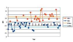
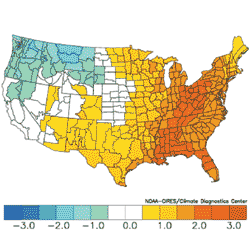
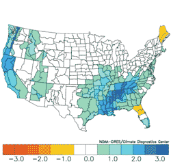
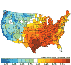
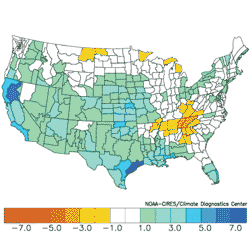
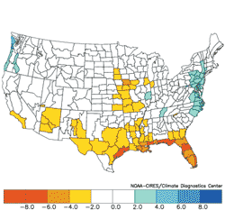
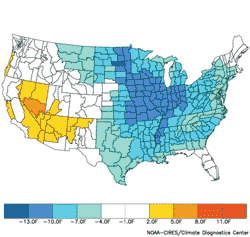
| Executive Summary: "Long-range climate prediction has become an essential tool for risk managers in planning seasonal, annual, and decadal supply and demand issues for the U.S. energy industry. These forecasts are based on the relationship of large-scale ocean and atmosphere change between specific points or regions correlated with climate. These environmental relationships are known as “climate teleconnections”. The primary climate teleconnections used to produce long-range climate predictions have transitioned through a phase change in recent years. This report lists a few of these changes and the implied U.S. climate anomalies. These climate changes represent billions of dollars in supply and demand issue to the U.S. energy market." Introduction Long-range climate prediction has grown in importance for the energy industry in recent years. Risk managers, economists, and engineers all require a “heads up” future view of how cold the winter season may be or the threat of extreme heat during the summer season to be best prepared for supply and demand issues. Long-range climate prediction is in its infancy as a consistently accurate predictive science. However, the importance of long-range forecasts to the energy industry has accelerated the learning curve of climate modelers and forecasters. One part of the accelerated learning curve is the improved understanding and application of climate teleconnections to future climate prediction. Climate teleconnections are meteorological and oceanographic measurements of sea level pressure, sea surface temperature, or winds aloft between specific points or regions across great distances evaluated on weekly, monthly, and seasonal time scales. Climate teleconnections help long-range forecasters explain prevailing weather patterns while providing a benchmark roadmap as to future predictions. One commonly known climate teleconnection is El Nino Southern Oscillation (ENSO). ENSO is the frequency of La Nina or El Nino events. Essentially, ENSO explains how involved the tropical (and subtropical) climate will be with mid-latitude weather systems. Other climate teleconnections given significant attention by the energy industry in recent years is the Pacific Decadal Oscillation (PDO) and Arctic Oscillation (AO). While ENSO describes the relationship of the equatorial Pacific Ocean sea surface to U.S. climate, the PDO correlates changing surface temperature and pressure patterns of the pole ward North Pacific Ocean on America’s prevailing weather patterns. AO is the monitoring of location and strength of the polar vortex, a key element is determining whether the winter season will be cold or mild. Generally, the North Atlantic Oscillation (NAO) is the part of the AO influence with the greatest effect on U.S. climate. Each of these climate teleconnections (and others) is evaluated closely to producing long-range climate predictions. Currently, the skill level at making these predictions allows forecasts to extend to 12-to-14 month time scales. Interestingly, forecast confidence can actually be higher at greater time scales versus shorter periods. The explanation is primarily due to time of year. Spring and autumn transition season generally render low confidence forecasts while winter and summer seasons frequently have above to well above average confidence. The goal of a long-range forecast to allow the user a view of a climate assessment for a target season based on the understanding and prediction of climate teleconnections. The practical goal is to forecast climate on the correct side of traditional 30-year climatology. There is great concern in the scientific community and energy industry regarding the affect of global warming on prevailing climate. This concern remains a great source of research. (One possible explanation is the effect of internal ocean warming producing milder polar climate). A practical application of the effect of global warming on long-range climate predictions is not yet available. Therefore the information contained within this document is based on what we’ve seen in the past applied to what we may see in the next two decades. Phase Change of Primary Climate Teleconnections Several climate teleconnections have undergone a phase change in the past few years. The primary climate teleconnections evaluated are the ENSO and PDO regimes. Observations regarding NAO trends are also mentioned. Finally, possibly the most important climate teleconnection (Ocean Thermohaline Conveyor Belt) is identified. The bulk of this report is simply a comparison of U.S. climate anomalies to negative and positive phases of each climate teleconnection with the implication that cold ENSO, negative PDO, and more frequent negative NAO events are expected through the next two decades. These climate regime changes are occasionally substantial. Many of these implied climate changes have already occurred. Keep in mind as you refer to national temperature and precipitation maps that follow, the climate change implied represents billions of dollars in supply and demand issues to the energy industry. El Nino Southern Oscillation (ENSO) The conventional driver of long-range climate prediction is the relationship of U.S. climate and the current ENSO phase. Considered during ENSO predictions made through next year is the long-term phase change of the late 1990’s from persistent warm ENSO episodes (El Nino) to a regime that spawns more neutral or cold ENSO episodes (La Nina). The previous cold ENSO regime (1949-1976) also implies that trends in El Nino events for the next two decades will feature limited strong El Nino events similar to the record- strength 1982-83 and 1997-98 episodes. This diminished warm ENSO intensity idea was applied to the expectation of a potential El Nino episode in 2002. If the El Nino occurs, the possibility of a major event (similar to 1982-83 and 1997-98) is highly unlikely. Graph 1 shows the trend in ENSO since 1950. Graph 1: Multivariate ENSO Index (MEI) is provided by the Climate Diagnostics Center (CDC). MEI is based on 6 observed variables over the tropical Pacific Ocean. Note the frequency of cold versus warm ENSO events of the 1950’s through mid-1970’s versus the past two decades. The lengthy La Nina of the late 1990’s identifies the beginning of the new (cold) ENSO long-term phase. A prevailing ENSO climate that favors the 1949-1976 (cold) regime versus the 1977-1998 (warm) scenario for the next two decades is implied by Graph 1. The difference in U.S. climate for the winter and summer season given these opposing ENSO phases is at least significant if not dramatically different. Charts 1 and 2 identify the average U.S. observed temperature anomalies for warm and cold ENSO meteorological winter (December through February). Charts 3 and 4 indicate differences in anomalous precipitation. (Note: Warm and cold ENSO events were determined by sea surface temperature anomalies in the Nino3, Nino4, and Nino3.4 ENSO monitoring areas. These locations are within 5° latitude of the equator between 175°W and 120°W. The period of 1950 to 1995 is used as a base climatology due to the expansive 50-year historic climate evaluated. All temperature and precipitation anomaly maps are provided by the Climate Diagnostics Center). Warm ENSO regimes typically bring very mild winters to the eastern U.S. while the northwest part of the nation is cooler than normal. Cold ENSO regimes produce a similar anomalous temperature pattern although less potent than with the El Nino regime. Warm ENSO winters are famous for producing wet and stormy regimes across the West Coast and southern states. Note that La Nina years typically shift the southern latitude anomalous wet pattern to the north to include the Tennessee and Ohio Valley while the southern states and West Coast are dry. On average, the cold ENSO (La Nina) climate will be typical of winters through the next two decades. Charts 1 and 2: Temperature anomaly comparison for Warm ENSO (El Nino) versus cold ENSO (La Nina) winter seasons. Analysis based on ENSO years chosen by the author of this report. Note the different resolution of the key in Chart 2. Charts 3 and 4: Precipitation anomaly comparison for Warm ENSO (El Nino) versus cold ENSO (La Nina) winter seasons. Note the different resolution of the key in Chart 4. Meteorological summer (June through August) national temperature and precipitation anomalies due to persistent cold and warm ENSO climate is shown in Charts 5 through 8. The temperature regime favors anomalous warmth during La Nina in the central U.S. while the Atlantic seaboard is cooler than normal. Note that the precipitation comparisons for the summer months are nearly opposite. The La Nina regime shown in Charts 2, 4, 6, and 8 is the favored climate through the next 2 decades.
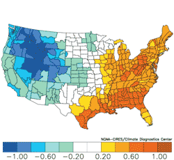
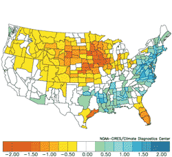
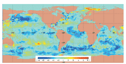
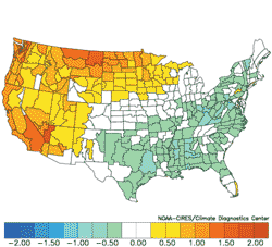
Charts 5 and 6: Temperature anomaly comparison for Warm ENSO (El Nino) versus cold ENSO (La Nina) summer seasons. Note the different resolution of the key in Chart 6. Charts 7 and 8: Precipitation anomaly comparison for Warm ENSO (El Nino) versus cold ENSO (La Nina) summer seasons. Pacific Decadal Oscillation (PDO) Pacific Decadal Oscillation (PDO) and ENSO cycles are related in that the most intense PDO signature is generally triggered by a mature ENSO event. Negative PDO regimes match cold ENSO and visa versa. The strongest PDO signatures occur during the mature phase of warm and cold ENSO episodes. An example is shown in Chart 9 where anomalous cold sea surface temperature (SST) stretches across the central and eastern Pacific Ocean showing a classic La Nina signature. This phenomenon leads to a large area of anomalous warm SST across the western Pacific Ocean extending east between 30 and 35 degrees at north and south latitude across the Pacific Ocean. This signature is a classic negative PDO signature usually accompanied by a mature La Nina event. Chart 9 shows a SST signature that may be dominant in the coming two decades. Typically, this SST signature spawns anomalous dry conditions across the southern U.S. potentially increasing the threat of summer heat in these areas. Charts 10 through 13 show an annual evaluation for moderate (or greater) strength negative and positive PDO regimes since 1950. The PDO index is plotted in Graph 2 and implied is a change toward a persistent negative PDO regime. The negative and positive PDO regimes have a 22 to 29 year life cycle. Chart 9: A mature phase La Nina (anomalous cold SST along the equator between 165°E and 90°W) is surrounded by a classic negative PDO signature (anomalous warm SST in the western Pacific and eastward between 30 and 35 north and south latitude). This SST signature is frequently referred to as the “horseshoe”. Charts 10 and 11: An annual temperature anomaly comparison for positive versus negative PDO regime is shown. Note the scale difference in Chart 11 key. Charts 12 and 13: An annual precipitation anomaly comparison for positive versus negative PDO regime is shown. Note the scale difference in Chart 13 key. Graph 2: The Pacific Decadal Oscillation (PDO) dating back to 1900 through February of 2001 is shown. Seasonal plots are also provided. PDO transitioned to its negative phase in the late 1990’ after a 22-year positive phase (1977-1998). The previous PDO phase was a negative regime that lasted from the late 1940’s to the middle 1970’s. North Atlantic Oscillation (NAO) The North Arctic Oscillation (NAO) is an index based on surface pressure comparison between the Azores and Iceland in the northern North Atlantic Ocean. NAO is more highly variable than ENSO and PDO with phase changes that occur every 10-to14 days. The differential implies strength and location of the polar jet stream. Negative NAO index indicates that the general circulation pattern across the North Atlantic depicts a “blocking” high-pressure ridge across Greenland. Upstream from this location (eastern North America) an upper long wave trough persists. This type of upper air trajectory is famous for delivering cold air across Canada into the U.S. east of the Continental Divide. The opposite scenario, a positive NAO, is present when a more zonal (west-to-east) jet stream pattern is in-place. The positive NAO regime generally prevents southward penetration of cold air masses across Canada into the U.S. and generally leaves the northern states much milder than normal. Charts 14 and 15 represent negative (cold December 2000) and positive (mild northern states in January 2001) NAO monthly regimes from last winter. Note the wide variation in month-to-month national temperature regime a shift in NAO brings. Charts 14 and 15: NAO index transitioned from a strong negative signature during December 2000 to a moderate positive phase in January 2001. The result was the 2nd coldest December on record followed by a month that produced near record anomalous mild temperature anomalies across North Dakota and Minnesota. Graph 3: The clustering of positive or negative NAO index on a monthly basis for the November through March cold season for alternating double solar cycles is shown. Alternating peak sunspot number occurring every 21 to 22 years represents a double solar cycle for this chart. A return to the 1959 to 1979 regime (more negative NAO events) is implied. Trends in NAO on a predictive basis are very difficult. However, there does seem to be a clustering of negative or positive monthly values for the cold season (November through March) occurring on alternating 22-year cycles. Peak sunspot numbers represents the beginning and ending point(s) of these cycles. Graph 3 depicts number of monthly negative versus positive NAO monthly observations from November to March for each solar cycle dating back to 1950. Note that the clustering of positive NAO events versus negative NAO events from 1980 to 2000 versus the opposite regime from 1959 to 1979. This observation was discovered while preparing a long-range forecast for potential Florida Citrus freeze events in 1999. The relationship between NAO (more appropriately AO) and solar activity is not known. However, given the peak sunspot number that occurred in late summer 2000 (ending the last double solar cycle) the implication was that an extreme negative NAO event should occur in winter 2000-2001. This prediction was quite bold given the persistent record mild winters of the late 1990’s. The burden on U.S. energy due to negative NAO (and cold U.S. climate) in November and December of 2000 was profound. Ocean Thermohaline Conveyor Belt The influence of the Oceanic Thermohaline Conveyor Belt (OTCB) has a clear influence on global climate. Table 1 describes the influence of OTCB (as researched by a noted oceanographer, Wally Broecker) on global climate. Clearly, this feature plays a large role in amounts of tropical cyclones across the North Atlantic Basin. Changing OTCB further substantiates the implied climate change detailed in this report due to shifting cycles in ENSO, PDO and character of NAO events. Table 1: Effect on global climate produced by OTCB phase change. *The 1994-2020 column is the Meteorlogix projection based on past trends through the year 2020. This report identifies the phase change in primary climate teleconnections used to quantify and predict prevailing monthly, seasonal, and annual climate regimes across the United States. Implied is moderate to dramatic change in persistent climate observed on a winter and summer seasonal time frame and annual basis. The change in persistent climate represents billions of dollars to the U.S. energy industry in supply and demand planning issues. The transition from a warm ENSO and positive PDO regime observed from 1977 to 1998 to a cold ENSO regime combined with persistent negative PDO implies that the benchmark climate of the next two decades may be similar to the 1949 to 1976 climate. The 1949 to 1976 climate plus the influence of global warming are the more proper forward decadal prediction. However, quantifying the influence of global warming to seasonal climate prediction is not yet known. Therefore this report essentially states that the persistent climate of the past 2 decades is ending and the character of persistent climate of the next 2 decades may be more representative of the 1950’s, 1960’s, and early 1970’s. The general climate change includes: 1) Increased tropical cyclone activity across the North Atlantic Basin also implying greater risk of intense hurricanes striking the U.S. Atlantic Seaboard, 2) Increased likelihood of drier and warmer annual climate across the eastern U.S. particularly the southeast states during summer, 3) Overall drier U.S. climate (leading to low regional soil moisture increasing the threat of extreme heat during summer), and 4) Increased frequency of negative NAO events spawning potential arctic outbreaks during the cold season. The climate teleconnections and related climate change described in this report are a cursory view of an immensely important and complex issue essential to U.S. energy supply and demand planning. Further research by specific energy companies to further detail climate change for specific data points or regional areas of interest is encouraged. | Composite Temperature Anomalies (F) Versus 1950-1995 Longterm Average Dec to Feb 1952-53, 1956-57, 1968-69, 1971-72, 1981-82, 1982-83, 1986-87, 1990-91, 1992-93, 1996-97
Composite Temperature Anomalies (F) Versus 1950-1995 Longterm Average Dec to Feb 1949-50, 1953-54, 1954-55, 1955-56, 1961-62, 1963-64, 1969-70, 1970-71, 1972-73, 1973-74, 1974-75, 1983-84, 1984-85, 1987-88, 1988-89, 1995-96, 1999-00
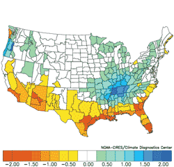
Composite Precipitation Anomalies (inches) Versus 1950-1995 Longterm Average Dec to Feb 1952-53, 1956-57, 1968-69, 1971-72, 1981-82, 1982-83, 1986-87, 1990-91, 1992-93, 1996-97
Composite Precipitation Anomalies (inches) Versus 1950-1995 Longterm Average Dec to Feb 1949-50, 1953-54, 1954-55, 1955-56, 1961-62, 1963-64, 1969-70, 1970-71, 1972-73, 1973-74, 1974-75, 1983-84, 1984-85, 1987-88, 1988-89, 1995-96, 1999-00
Composite Temperature Anomalies (F) Versus 1950-1995 Longterm Average Jun to Aug 1953,1957, 1965, 1969, 1972, 1982, 1983, 1987, 1991, 1993, 1997
Composite Temperature Anomalies (F) Versus 1950-1995 Longterm Average Jun to Aug 1950, 1954, 1955, 1956, 1962, 1964, 1970, 1971, 1973, 1974, 1975, 1984, 1985, 1988, 1989, 1996, 2000
Composite Precipitation Anomalies (inches) Versus 1950-1995 Longterm Average Jun to Aug 1953,1957, 1965, 1969, 1972, 1982, 1983, 1987, 1991, 1993, 1997
Composite Precipitation Anomalies (inches) Versus 1950-1995 Longterm Average Jun to Aug 1950, 1954, 1955, 1956, 1962, 1964, 1970, 1971, 1973, 1974, 1975, 1984, 1985, 1988, 1989, 1996, 2000
FNMOC OTIS 4.0: SST-NCEP CLimate Anomaly (C) 23 Jan 2001 12Z
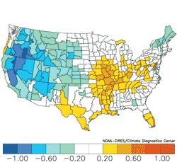
Composite Temperature Anomalies (F) Versus 1950-1995 Longterm Average Jan to Dec 1958, 1979, 1980, 1981, 1983, 1984, 1986, 1987, 1992, 1993, 1995, 1997
Composite Temperature Anomalies (F) Versus 1950-1995 Longterm Average Jan to Dec 1950, 1952, 1955, 1956, 1962, 1967, 1971, 1973, 1975, 1999, 2000
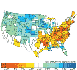
Composite Precipitation Anomalies (inches) Versus 1950-1995 Longterm Average Jan to Dec 1958, 1979, 1980, 1981, 1983, 1984, 1986, 1987, 1992, 1993, 1995, 1997
Composite Precipitation Anomalies (inches) Versus 1950-1995 Longterm Average Jan to Dec 1950, 1952, 1955, 1956, 1962, 1967, 1971, 1973, 1975, 1999, 2000
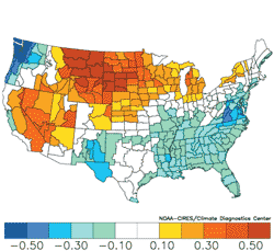
Temperature Anomalies Dec 2000 Versus 1950-1995 Longterm Average
Temperature Anomalies Jan 2000 Versus 1950-1995 Longterm Average
|

About The Author
Scott Yuknis is the Lead Long-range Climate Forecaster at Meteorlogix, one of the worlds leading suppliers of meteorological data and weather forecast information. Meteorlogix medium and long-range forecasts (including the winter 2001-2002) can be viewed on www.climatetrends.com.
Information Sources
Climate Prediction Center (CPC), Climate Diagnostics Center (CDC), International Research Institute (IRI) for Climate Prediction, European Center for Medium-range Weather Forecasts (ECMWF), Australia National Meteorological and Oceanography Center, Fleet Numerical Oceanography Center (FNOC), NASA, Canadian Meteorological Center, Center for Ocean and Atmosphere Prediction Science (COAPS), Colorado State University, and University of Washington.
Scott A. Yuknis, Senior Meteorologist
Long-range Climate Prediction
Meteorlogix
420 Bedford Street, Boston, MA 02420
781-676-1208
Scott.Yuknis@meteorlogix.com