
Most electric utilities have implemented either a Geographic Information System (GIS) or some type of mapping system. Many maintain an asset management system. A small but rapidly growing number are implementing field-based staking (design) systems. Automated field staking provides the mechanism to greatly increase productivity and enable digital GIS and asset management updates. Creating digital GIS and asset management (hereafter collectively termed ‘GIS’) data at the real-world source (out in the field) effectively removes the impediments and time required to maintain those, and many other systems.
There is a tremendous amount of data that typically gets transcribed a number of times in order to maintain a utility’s GIS. It does not require much analysis to realize the benefits of enabling that same original data to suddenly go twice as far. This is what happens when you extend the data gathered by a field staking system into a GIS. The obvious advantage to the staking or design engineer is bringing a computerized and automated staking and work order automation system into the field with GIS facility maps. The tremendous advantage from the GIS perspective is keeping a near realtime updated GIS data set reflecting proposed, changed, retired and newly constructed field designs – the vast majority of all GIS data manipulations. By leveraging a field staking system and an interface to the utility GIS, creating data in the field can be twice as valuable.
The GIS Implementation Conundrum
Electric utilities make strategic decisions to invest in and implement a GIS. To fully capitalize on this investment it is imperative to not only integrate the GIS with other systems and processes, but to also maintain the data it holds. GIS data population is typically accomplished in two phases. The initial population starts with field collection and generally takes anywhere from one to five years to complete. An inherent problem with this data collection phase stems from the continuous construction and system changes occurring throughout the system during the field collection process. Ultimately, a field collection project without an accompanying update process just creates a single point-in-time representation of the inventoried assets. After the field collection is complete, there is a continual need for data maintenance due to ongoing system upgrades, changes and new construction.
The second GIS population phase involves ongoing GIS maintenance. This data maintenance is driven by several change sources, each with unique update frequencies. The first and most static data source are land base features. These are often created by city and county governments and include political boundaries, road projects and government facilities. Many utilities have procedures in place to handle such changes. However, due to the infrequent nature of land base modifications, utilities do not usually need to automate this process. The second source of base-map data change involves construction and development including new plats, roads and address changes. These modifications often require automated procedures depending upon how much new construction is occurring within the utility’s service territory. Finally, it is the daily work on the utility infrastructure – such as upgrades, retirements and plant additions – that necessitates an automated process for data collection, work management and transferring the resulting changes to the GIS data set. Without an updating procedure in place, the static GIS dataset gets further away from reflecting the actual environment with each closed out work order and service order. The high frequency of system changes and the fact that the majority of these changes are internal to a utility creates an opportunity for a large return on investment when looking at automated field staking systems.
Field Staking and GIS
Duplication of effort is, unfortunately, almost always part of existing GIS maintenance efforts. The most common approach is to reference staking sheets or as-built drawings and manually re-digitize the data, duplicating the effort of the staking engineer who created the design in the first place. Another common approach is to return to the field after construction to obtain GPS readings and inventory the as-built assets with GPS data-logging field units. When these labor intensive updating procedures are not in place the unfortunate alternative – after a number of years of unrecorded system changes – is to re-inventory the entire territory, an expensive proposition that means a utility is again relying on outdated, one to five year old data. More significantly, both approaches require manually re-manipulating data that was used during the field design and work order process.
Field staking systems are a real alternative source for GIS data maintenance that have been proven cost effective in hundreds of electric utilities to date. These systems enable the utility to use data gathered during the work order process and digitally update the GIS. They effectively extend the GIS to actual design work in the field, without encumbering the field user with the speed and functional impediments inherent to analytical GIS programs. Creating system designs in the field, where assets are positioned and can be referenced against the reality of the environment where they will be built, not only makes a powerful contribution to the overall accuracy of the GIS data but also makes for a cleaner, more accurate design that is easier for construction crews to interpret and build. This leads to better construction that adheres to the staking engineer’s design, fewer as-built changes and less overall time spent during the entire work order process.
Contrast the field staking approach to designing in the office from memory. Relying only on GIS data often results in overlooking or imprecisely portraying the relationship between the design and the environment in which it is to be built. In-office design systems are typically built on top of a GIS engine. Implementing this approach requires significant training and an interface built around GIS-centric tools that were built for editing GIS data instead of being design focused. A major portion of the value of a GIS comes not just from the maps, but the relationship between data that are represented and the real world. Imprecise, non-field checked designs lead to change orders, reconfigurations, re-builds and ultimately higher costs.
The Payback Model
A field staking and work order automation system has a compelling value proposition. Utilities implementing field staking typically calculate a complete return on investment within a six month to two year time frame. This enables field staking systems to be deployed on a cash-neutral basis from the utility’s standpoint and to generate actual return on equity after the break even point is needed. The following analysis demonstrates portions of the value proposition.
A utility’s GIS is dynamic, like the utility itself. The daily changes that occur in the GIS reflects the operation of the utility it supports. Depending on the size of the utility, as illustrated in Figure 2, “Yearly Changes (GIS Entities),” the potential for changes within a GIS due to field work can be significant. Modifications to existing plant, new plant additions and replacement or retirement of existing facilities represent the vast majority of GIS data changes. Automating the data updating processes removes much of the mundane, repetitive data entry workload from GIS personnel and allows them to concentrate on critical business processes and analysis. Figure 3, “GIS Data Maintenance Resources” illustrates the dramatic workload reduction that can be achieved through integration of field staking data into the GIS.
Automating the work order process using field staking tools generates savings throughout the utility beyond the direct GIS benefits. Figure 4, “Cost Benefit Analysis,” illustrates a typical utility calculation showing the time savings realized on a 30 station work order. This analysis takes into account the ability to perform cost estimates in the field for the customer, GIS integration, avoiding multiple trips to the job site, reduced error rates and process improvements. Extrapolating the savings realized on this particular type of work order provide compelling reasons to implement a field staking system.
Improved Return from GIS
Leveraging field staking systems and GIS also benefits the design process itself. Staking engineers can bring the entire GIS feature set to the field to use as the basis for the design. This helps orient and inform the designer by visually providing existing information and gives an in-field opportunity to verify the GIS data. Staking out a design in the field also results in the final design reflecting a high degree of positional accuracy. Adding field measurement tools such as real time differential GPS receivers and highly accurate laser range finders dramatically improves the quality of the GIS geo-referenced data. The incorporation of these tools in the staking process also significantly speeds up the actual design process itself.
A slight change in a utility’s approach towards GIS maintenance, by directly incorporating field staking data, will lead to tremendous productivity gains. This can be done without disrupting the rest of the work order process. Deployed correctly, staking designs continue to be processed through the normal work order channels using and automating procedures with the digital data where possible or practical. As the staking designs flow through the existing work order process, the GIS system can be used to analyze and visualize the status of work at various stages. By dynamically acquiring data from the work order / staking system, real-time changes are available for reference through the GIS. For example, it can sometimes take over a year for a design to move from original sketch to completed construction close out. The need to reference designs or construction in progress may arise several times before the proposed design is posted permanently to the GIS. The ability to reference proposed changes throughout the process increases accuracy and reduces the amount of time needed to get a current picture of a project’s status.
Concerns about the quality of the posted data can be addressed through internal quality control procedures. By carrying the staking design changes through the work order process, adjustments that reflect as-built construction can be made before the final data is posted to the GIS, yet is available for reference while pending. In office design engineers and cartographers can clean-up the data by previewing and posting the final design to the GIS system. This way the final data, connectivity and cartographic decisions remain in the hands of the GIS personnel. This crucial step ensures maintenance of data integrity and results in ‘good-looking’ maps. Requiring this edit/approval step prior to posting ensures quality assurance rules are applied without duplicate data entry of the field design work.
The Timeline for Return
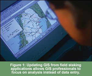
Using field based staking tools in conjunction with a GIS helps lower the barrier for a utility to begin GIS implementation. Many utilities are put off by the large up front cost of setting up, populating and maintaining a GIS. Using the data from a field staking tool can form the foundation of a complete GIS by starting down the path of having intelligent map data available. Instituting a work order automation and field staking system before or even during GIS implementation allows a best-practice approach to be developed before the GIS staff becomes inundated with trying to run the system. It also allows GIS professionals time to focus on data analysis, trends and system operation, not simply updating graphics and data. All of this leads to reaping an early return on investment.
Those utilities already in the middle of deploying their GIS can reap benefits by using the data collected by the field designed work orders. As already mentioned, most GIS attributes are automatically collected by the staking engineer during the design process. Strategic decisions and investments are oftentimes made and determined by analyzing GIS data. Formulating a good plan for automated data maintenance before starting a GIS project can allow utilities to reap value from a GIS in the near-term, even before the comprehensive implementation is complete.
Utilities are under increasing pressure to do more with less. Bringing information that is part of the field design and work order process into the GIS increases accuracy, removes redundant data entry, and speeds the return on the GIS investment. Updating the GIS on a frequent basis and adding geographic and on-location visibility into designs, from sketching to close out, provides the opportunity for advanced analysis on how a utility’s infrastructure is developed and maintained. By leveraging the technology, work done in the field can now go twice as far.
ABOUT THE AUTHOR ABOUT THE AUTHOR
Sean Solberg is the Vice President of Research and Development for MiniMax Corporation. MiniMax is the leading provider of field productivity tools to the utility industry. Its flagship product, StakeOut, automates the design, staking and work order process from design to construction. Mr. Solberg oversees the continuing development MiniMax’s product line including StakeOut and GIS integration. For further information see www.minimax.net.
There is a tremendous amount of data that typically gets transcribed a number of times in order to maintain a utility’s GIS. It does not require much analysis to realize the benefits of enabling that same original data to suddenly go twice as far. This is what happens when you extend the data gathered by a field staking system into a GIS. The obvious advantage to the staking or design engineer is bringing a computerized and automated staking and work order automation system into the field with GIS facility maps. The tremendous advantage from the GIS perspective is keeping a near realtime updated GIS data set reflecting proposed, changed, retired and newly constructed field designs – the vast majority of all GIS data manipulations. By leveraging a field staking system and an interface to the utility GIS, creating data in the field can be twice as valuable.
The GIS Implementation Conundrum
Electric utilities make strategic decisions to invest in and implement a GIS. To fully capitalize on this investment it is imperative to not only integrate the GIS with other systems and processes, but to also maintain the data it holds. GIS data population is typically accomplished in two phases. The initial population starts with field collection and generally takes anywhere from one to five years to complete. An inherent problem with this data collection phase stems from the continuous construction and system changes occurring throughout the system during the field collection process. Ultimately, a field collection project without an accompanying update process just creates a single point-in-time representation of the inventoried assets. After the field collection is complete, there is a continual need for data maintenance due to ongoing system upgrades, changes and new construction.
The second GIS population phase involves ongoing GIS maintenance. This data maintenance is driven by several change sources, each with unique update frequencies. The first and most static data source are land base features. These are often created by city and county governments and include political boundaries, road projects and government facilities. Many utilities have procedures in place to handle such changes. However, due to the infrequent nature of land base modifications, utilities do not usually need to automate this process. The second source of base-map data change involves construction and development including new plats, roads and address changes. These modifications often require automated procedures depending upon how much new construction is occurring within the utility’s service territory. Finally, it is the daily work on the utility infrastructure – such as upgrades, retirements and plant additions – that necessitates an automated process for data collection, work management and transferring the resulting changes to the GIS data set. Without an updating procedure in place, the static GIS dataset gets further away from reflecting the actual environment with each closed out work order and service order. The high frequency of system changes and the fact that the majority of these changes are internal to a utility creates an opportunity for a large return on investment when looking at automated field staking systems.
Field Staking and GIS
Duplication of effort is, unfortunately, almost always part of existing GIS maintenance efforts. The most common approach is to reference staking sheets or as-built drawings and manually re-digitize the data, duplicating the effort of the staking engineer who created the design in the first place. Another common approach is to return to the field after construction to obtain GPS readings and inventory the as-built assets with GPS data-logging field units. When these labor intensive updating procedures are not in place the unfortunate alternative – after a number of years of unrecorded system changes – is to re-inventory the entire territory, an expensive proposition that means a utility is again relying on outdated, one to five year old data. More significantly, both approaches require manually re-manipulating data that was used during the field design and work order process.
Figure 2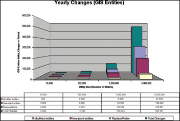
Field staking systems are a real alternative source for GIS data maintenance that have been proven cost effective in hundreds of electric utilities to date. These systems enable the utility to use data gathered during the work order process and digitally update the GIS. They effectively extend the GIS to actual design work in the field, without encumbering the field user with the speed and functional impediments inherent to analytical GIS programs. Creating system designs in the field, where assets are positioned and can be referenced against the reality of the environment where they will be built, not only makes a powerful contribution to the overall accuracy of the GIS data but also makes for a cleaner, more accurate design that is easier for construction crews to interpret and build. This leads to better construction that adheres to the staking engineer’s design, fewer as-built changes and less overall time spent during the entire work order process.
Contrast the field staking approach to designing in the office from memory. Relying only on GIS data often results in overlooking or imprecisely portraying the relationship between the design and the environment in which it is to be built. In-office design systems are typically built on top of a GIS engine. Implementing this approach requires significant training and an interface built around GIS-centric tools that were built for editing GIS data instead of being design focused. A major portion of the value of a GIS comes not just from the maps, but the relationship between data that are represented and the real world. Imprecise, non-field checked designs lead to change orders, reconfigurations, re-builds and ultimately higher costs.
The Payback Model
A field staking and work order automation system has a compelling value proposition. Utilities implementing field staking typically calculate a complete return on investment within a six month to two year time frame. This enables field staking systems to be deployed on a cash-neutral basis from the utility’s standpoint and to generate actual return on equity after the break even point is needed. The following analysis demonstrates portions of the value proposition.
A utility’s GIS is dynamic, like the utility itself. The daily changes that occur in the GIS reflects the operation of the utility it supports. Depending on the size of the utility, as illustrated in Figure 2, “Yearly Changes (GIS Entities),” the potential for changes within a GIS due to field work can be significant. Modifications to existing plant, new plant additions and replacement or retirement of existing facilities represent the vast majority of GIS data changes. Automating the data updating processes removes much of the mundane, repetitive data entry workload from GIS personnel and allows them to concentrate on critical business processes and analysis. Figure 3, “GIS Data Maintenance Resources” illustrates the dramatic workload reduction that can be achieved through integration of field staking data into the GIS.
Automating the work order process using field staking tools generates savings throughout the utility beyond the direct GIS benefits. Figure 4, “Cost Benefit Analysis,” illustrates a typical utility calculation showing the time savings realized on a 30 station work order. This analysis takes into account the ability to perform cost estimates in the field for the customer, GIS integration, avoiding multiple trips to the job site, reduced error rates and process improvements. Extrapolating the savings realized on this particular type of work order provide compelling reasons to implement a field staking system.
Figure 3
Improved Return from GIS
Leveraging field staking systems and GIS also benefits the design process itself. Staking engineers can bring the entire GIS feature set to the field to use as the basis for the design. This helps orient and inform the designer by visually providing existing information and gives an in-field opportunity to verify the GIS data. Staking out a design in the field also results in the final design reflecting a high degree of positional accuracy. Adding field measurement tools such as real time differential GPS receivers and highly accurate laser range finders dramatically improves the quality of the GIS geo-referenced data. The incorporation of these tools in the staking process also significantly speeds up the actual design process itself.
Figure 4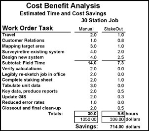
A slight change in a utility’s approach towards GIS maintenance, by directly incorporating field staking data, will lead to tremendous productivity gains. This can be done without disrupting the rest of the work order process. Deployed correctly, staking designs continue to be processed through the normal work order channels using and automating procedures with the digital data where possible or practical. As the staking designs flow through the existing work order process, the GIS system can be used to analyze and visualize the status of work at various stages. By dynamically acquiring data from the work order / staking system, real-time changes are available for reference through the GIS. For example, it can sometimes take over a year for a design to move from original sketch to completed construction close out. The need to reference designs or construction in progress may arise several times before the proposed design is posted permanently to the GIS. The ability to reference proposed changes throughout the process increases accuracy and reduces the amount of time needed to get a current picture of a project’s status.
Concerns about the quality of the posted data can be addressed through internal quality control procedures. By carrying the staking design changes through the work order process, adjustments that reflect as-built construction can be made before the final data is posted to the GIS, yet is available for reference while pending. In office design engineers and cartographers can clean-up the data by previewing and posting the final design to the GIS system. This way the final data, connectivity and cartographic decisions remain in the hands of the GIS personnel. This crucial step ensures maintenance of data integrity and results in ‘good-looking’ maps. Requiring this edit/approval step prior to posting ensures quality assurance rules are applied without duplicate data entry of the field design work.
The Timeline for Return
Using field based staking tools in conjunction with a GIS helps lower the barrier for a utility to begin GIS implementation. Many utilities are put off by the large up front cost of setting up, populating and maintaining a GIS. Using the data from a field staking tool can form the foundation of a complete GIS by starting down the path of having intelligent map data available. Instituting a work order automation and field staking system before or even during GIS implementation allows a best-practice approach to be developed before the GIS staff becomes inundated with trying to run the system. It also allows GIS professionals time to focus on data analysis, trends and system operation, not simply updating graphics and data. All of this leads to reaping an early return on investment.
Those utilities already in the middle of deploying their GIS can reap benefits by using the data collected by the field designed work orders. As already mentioned, most GIS attributes are automatically collected by the staking engineer during the design process. Strategic decisions and investments are oftentimes made and determined by analyzing GIS data. Formulating a good plan for automated data maintenance before starting a GIS project can allow utilities to reap value from a GIS in the near-term, even before the comprehensive implementation is complete.
Utilities are under increasing pressure to do more with less. Bringing information that is part of the field design and work order process into the GIS increases accuracy, removes redundant data entry, and speeds the return on the GIS investment. Updating the GIS on a frequent basis and adding geographic and on-location visibility into designs, from sketching to close out, provides the opportunity for advanced analysis on how a utility’s infrastructure is developed and maintained. By leveraging the technology, work done in the field can now go twice as far.
ABOUT THE AUTHOR ABOUT THE AUTHOR
Sean Solberg is the Vice President of Research and Development for MiniMax Corporation. MiniMax is the leading provider of field productivity tools to the utility industry. Its flagship product, StakeOut, automates the design, staking and work order process from design to construction. Mr. Solberg oversees the continuing development MiniMax’s product line including StakeOut and GIS integration. For further information see www.minimax.net.