
Introduction
Developments in GPS (the Global Positioning System) and DGPS (Differential GPS) over the last few years have greatly changed the options for geo-location procedures in the survey and utilities mapping industry. Full availability of GPS signal and varied choices for differential corrections, together with competitive pricing for good quality DGPS receivers and data logging equipment, mean that high accuracy real time positioning is available for relatively low cost. In addition, due to advances in technology and changing government initiatives, the choices available are continuously evolving. Recent developments have also brought about significant increases in available accuracy at reduced cost. This article addresses some of the latest developments in the field of GPS/DGPS and the options available to system users.
Differential GPS and the Removal of SA
Outside a brief period in the early 1990’s during Desert Storm the accuracy available to civilian and other non-authorized users of GPS had been deliberately degraded by the United States Department of Defense (US DOD) for reasons of national security. This accuracy degradation, known as Selective Availability or SA, limited the horizontal positioning accuracy of a stand alone GPS for most users to approximately +/- 100 meters. To overcome the effects of SA differential techniques were applied (DGPS). DGPS involved the use of GPS receivers placed at known locations to measure systematic errors (of which SA was the greatest). These error measurements could then be applied to the position calculations for unknown locations to derive a much more accurate result. Differential corrections could be applied using post processing techniques or in real time if an adequate data link existed between the reference station(s) and the user. Using differential techniques and good quality DGPS instruments the effects of SA could effectively be removed resulting in horizontal accuracies of better than +/- 1 meter.
Virtually all GIS and utilities mapping users require accuracy of better than +/- 100 meters and the use of Differential techniques was therefore a necessity.
On May 1st 2000 the US DOD removed SA. This was the single largest source of error in GPS positioning so the first reaction of many GPS users was: "Do I still need to use Differential Techniques?".
Subsequent measurements, after the removal of SA, indicate that horizontal accuracies of approximately +/- 7-10 meters can be achieved with a good quality GPS receiver. Another important but potentially misleading change is a considerable improvement in short term positioning stability. This can lead to overestimates of accuracy if only short period data sets are used for analysis.
Results from lower quality receivers, such as hand held devices, are significantly less good. Interestingly, stand-alone performance differences between receivers now SA is off are greater than the variations in differential performance prior to the removal of SA.
Despite this significant improvement in stand-alone accuracy, it still does not meet the requirements of most GIS users, therefore differential techniques continue to be used for most applications.
Although the removal of SA has not changed the need for differential corrections it has made the use of real time DGPS more robust. With SA on, systematic errors changed rapidly and differential corrections had to be updated continuously. If a new differential correction was not received within, say, 30 seconds, then the position degraded very rapidly to nondifferential quality. With SA switched off the rate of change of GPS errors (now largely caused by atmospheric conditions) is much slower. This means that, provided sufficient GPS satellites remain in view, a good position may be calculated for several minutes without the need for frequent differential updates. In areas where differential signal blockage occurs, such as under tree canopy or in downtown “canyons”, the removal of SA has meant that this blockage is less of a problem. One good differential correction can be used for several minutes without a significant degradation in positioning accuracy, provided enough GPS satellites remain available.
Differential Correction Sources – WAAS, Beacon, Commercial
Assuming horizontal accuracies of better than +/- 8 meters are required then differential corrections are still needed to remove the errors in GPS caused by atmospheric effects and system perturbations.
The main choices are: (i) provide your own differential signal (by buying a radio data link and another GPS receiver as a reference unit) or (ii) use a signal provided by a third party. Most DGPS users are now using signals provided by a third party as these are widely available and minimize the capital expenditure and logistic support required by a user owned system. ‘Free’ tax payer funded systems are attractive due to the lack of a user fee, but their performance and reliability do not match those of the commercial providers. To summarize, here is a list of the pros and cons of the various methods:
Tower networks and FM sideband providers are virtually non-existent having been rendered uncompetitive by the tax-payer funded systems. WAAS the Wide Area Augmentation System - is currently the greatest ‘unknown’ in the mix. In addition to being ‘free’ (although it has already cost the American taxpayer well over 1 billion dollars with on-going costs of nearly $100M a year!) its great advantage is the wide area of coverage. Being satellite delivered, this is expected to equal that already provided by the commercial satellite suppliers. However, accuracy and stability tests so far indicate that it does not provide the same levels of performance as those achieved by the commercial suppliers and, due to satellite selection, coverage is less good at Northern latitudes. Horizontal accuracy using a good commercial satellite service (such as OmniSTAR) and a good DGPS receiver should be consistently sub meter (ie: < +/- 1 meter 3 sigma). Although short term stability with WAAS appears to be quite good there may be times during the day when it can be over 2 meters off location for extended periods.
So, as always, the user has to decide how critical the job specifications are and select the system to meet these specs. For non-critical work a government supplied differential service and relatively low cost handheld GPS receiver could be more than adequate. For projects where the specifications require maximum absolute and repeatable accuracy then a high grade GPS receiver coupled with a commercial differential correction service would be the best choice.
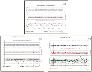
The following charts indicate the different levels of performance between coast guard beacon (at - 40 miles), WAAS (on a relatively good day) and commercial satellite differential (the coast guard signal was affected by thunderstorm activity for part of the 24 hour period).
Higher Accuracy Options in Real Time DGPS
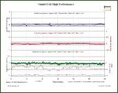
During the last quarter of 2002 options for even higher precision differential services have become commercially available. Some of these services, when combined with a suitable dual frequency DGPS L1/L2 receiver, can provide horizontal positioning accuracies of < +/- 10 cms.
This latest development represents something of a breakthrough in real time positioning techniques because hitherto it has been necessary to use expensive and challenging RTK techniques to reach these levels of accuracy.
The next plot indicates the significantly improved accuracy available from a dual frequency wide area solution (note the different scale):
Hardware Choices
Another important choice for the DGPS user is type of hardware. The two main categories are: relatively inexpensive hand held devices which nonetheless have built-in data logging and processing capabilities, or more expensive instruments which require a backpack.
Again, the key question is the required measurement specifications for the work. Handheld devices, although inexpensive, easy to use, and amazingly sophisticated for the size and price, are inevitably limited in the level of positioning accuracy they can achieve due to engineering compromises made to reduce size and weight. Backpack units, with separate high quality antennas, and designed for maximum accuracy, deliver much greater accuracy but are more expensive and more complex to operate.
Generally speaking the horizontal accuracy of hand held receivers is in the +/- 3 – 5 meter range, whereas back pack units can provide consistent sub meter results (with a good differential correction).
Summary
Recent developments, such as the removal of SA and the introduction of WAAS, together with the availability of high accuracy wide area solutions from commercial suppliers, mean that careful consideration must be given to equipment and service performance to ensure that systems deployed are sufficient to meet job requirements.
Developments in GPS (the Global Positioning System) and DGPS (Differential GPS) over the last few years have greatly changed the options for geo-location procedures in the survey and utilities mapping industry. Full availability of GPS signal and varied choices for differential corrections, together with competitive pricing for good quality DGPS receivers and data logging equipment, mean that high accuracy real time positioning is available for relatively low cost. In addition, due to advances in technology and changing government initiatives, the choices available are continuously evolving. Recent developments have also brought about significant increases in available accuracy at reduced cost. This article addresses some of the latest developments in the field of GPS/DGPS and the options available to system users.
Differential GPS and the Removal of SA
Outside a brief period in the early 1990’s during Desert Storm the accuracy available to civilian and other non-authorized users of GPS had been deliberately degraded by the United States Department of Defense (US DOD) for reasons of national security. This accuracy degradation, known as Selective Availability or SA, limited the horizontal positioning accuracy of a stand alone GPS for most users to approximately +/- 100 meters. To overcome the effects of SA differential techniques were applied (DGPS). DGPS involved the use of GPS receivers placed at known locations to measure systematic errors (of which SA was the greatest). These error measurements could then be applied to the position calculations for unknown locations to derive a much more accurate result. Differential corrections could be applied using post processing techniques or in real time if an adequate data link existed between the reference station(s) and the user. Using differential techniques and good quality DGPS instruments the effects of SA could effectively be removed resulting in horizontal accuracies of better than +/- 1 meter.
Virtually all GIS and utilities mapping users require accuracy of better than +/- 100 meters and the use of Differential techniques was therefore a necessity.
On May 1st 2000 the US DOD removed SA. This was the single largest source of error in GPS positioning so the first reaction of many GPS users was: "Do I still need to use Differential Techniques?".
Subsequent measurements, after the removal of SA, indicate that horizontal accuracies of approximately +/- 7-10 meters can be achieved with a good quality GPS receiver. Another important but potentially misleading change is a considerable improvement in short term positioning stability. This can lead to overestimates of accuracy if only short period data sets are used for analysis.
Results from lower quality receivers, such as hand held devices, are significantly less good. Interestingly, stand-alone performance differences between receivers now SA is off are greater than the variations in differential performance prior to the removal of SA.
Despite this significant improvement in stand-alone accuracy, it still does not meet the requirements of most GIS users, therefore differential techniques continue to be used for most applications.
Although the removal of SA has not changed the need for differential corrections it has made the use of real time DGPS more robust. With SA on, systematic errors changed rapidly and differential corrections had to be updated continuously. If a new differential correction was not received within, say, 30 seconds, then the position degraded very rapidly to nondifferential quality. With SA switched off the rate of change of GPS errors (now largely caused by atmospheric conditions) is much slower. This means that, provided sufficient GPS satellites remain in view, a good position may be calculated for several minutes without the need for frequent differential updates. In areas where differential signal blockage occurs, such as under tree canopy or in downtown “canyons”, the removal of SA has meant that this blockage is less of a problem. One good differential correction can be used for several minutes without a significant degradation in positioning accuracy, provided enough GPS satellites remain available.
Differential Correction Sources – WAAS, Beacon, Commercial
Assuming horizontal accuracies of better than +/- 8 meters are required then differential corrections are still needed to remove the errors in GPS caused by atmospheric effects and system perturbations.
The main choices are: (i) provide your own differential signal (by buying a radio data link and another GPS receiver as a reference unit) or (ii) use a signal provided by a third party. Most DGPS users are now using signals provided by a third party as these are widely available and minimize the capital expenditure and logistic support required by a user owned system. ‘Free’ tax payer funded systems are attractive due to the lack of a user fee, but their performance and reliability do not match those of the commercial providers. To summarize, here is a list of the pros and cons of the various methods:
| Pros | Cons | |
| Own signal | You have control Potential for maximum accuracy | Capital Investment Logistic support More to go wrong |
| Tower Network | Potential for maximum accuracy Local support | Limited coverage Not widely available |
| FM Sideband | Potential for maximum accuracy Lightweight Relatively low up front cost | Limited coverage Not widely available |
| Coast Guard | Relatively low up front cost ‘Free' signal | Limited coverage Variable Accuracy Weather Interference No guarantees |
| WAAS | Wide area of Coverage Relatively low up front cost ‘Free' signal | Variable Accuracy No guarantees Questionable Future |
| Commercial Satellite Signal | Maximum Accuracy Global Coverage Reliable signal Customer Support New High Performance Options | Annual Subscription Fee |
Tower networks and FM sideband providers are virtually non-existent having been rendered uncompetitive by the tax-payer funded systems. WAAS the Wide Area Augmentation System - is currently the greatest ‘unknown’ in the mix. In addition to being ‘free’ (although it has already cost the American taxpayer well over 1 billion dollars with on-going costs of nearly $100M a year!) its great advantage is the wide area of coverage. Being satellite delivered, this is expected to equal that already provided by the commercial satellite suppliers. However, accuracy and stability tests so far indicate that it does not provide the same levels of performance as those achieved by the commercial suppliers and, due to satellite selection, coverage is less good at Northern latitudes. Horizontal accuracy using a good commercial satellite service (such as OmniSTAR) and a good DGPS receiver should be consistently sub meter (ie: < +/- 1 meter 3 sigma). Although short term stability with WAAS appears to be quite good there may be times during the day when it can be over 2 meters off location for extended periods.
So, as always, the user has to decide how critical the job specifications are and select the system to meet these specs. For non-critical work a government supplied differential service and relatively low cost handheld GPS receiver could be more than adequate. For projects where the specifications require maximum absolute and repeatable accuracy then a high grade GPS receiver coupled with a commercial differential correction service would be the best choice.
The following charts indicate the different levels of performance between coast guard beacon (at - 40 miles), WAAS (on a relatively good day) and commercial satellite differential (the coast guard signal was affected by thunderstorm activity for part of the 24 hour period).
Higher Accuracy Options in Real Time DGPS
During the last quarter of 2002 options for even higher precision differential services have become commercially available. Some of these services, when combined with a suitable dual frequency DGPS L1/L2 receiver, can provide horizontal positioning accuracies of < +/- 10 cms.
This latest development represents something of a breakthrough in real time positioning techniques because hitherto it has been necessary to use expensive and challenging RTK techniques to reach these levels of accuracy.
The next plot indicates the significantly improved accuracy available from a dual frequency wide area solution (note the different scale):
Hardware Choices
Another important choice for the DGPS user is type of hardware. The two main categories are: relatively inexpensive hand held devices which nonetheless have built-in data logging and processing capabilities, or more expensive instruments which require a backpack.
Again, the key question is the required measurement specifications for the work. Handheld devices, although inexpensive, easy to use, and amazingly sophisticated for the size and price, are inevitably limited in the level of positioning accuracy they can achieve due to engineering compromises made to reduce size and weight. Backpack units, with separate high quality antennas, and designed for maximum accuracy, deliver much greater accuracy but are more expensive and more complex to operate.
Generally speaking the horizontal accuracy of hand held receivers is in the +/- 3 – 5 meter range, whereas back pack units can provide consistent sub meter results (with a good differential correction).
Summary
Recent developments, such as the removal of SA and the introduction of WAAS, together with the availability of high accuracy wide area solutions from commercial suppliers, mean that careful consideration must be given to equipment and service performance to ensure that systems deployed are sufficient to meet job requirements.