Vegetation failure is one of the leading causes of service outages, according to data from utilities and other organizations that track utility infrastructure. Not only is vegetation failure a significant safety risk to the public and employees tasked with maintenance, it also exposes utilities to extreme liability when considering catastrophic consequences, such as wildfires and cascading blackouts, and results in increased costs, decreased revenue and a spike in dissatisfied customers.
For more than 100 years, utility vegetation management (VM) practitioners have utilized a variety of data to both optimize and streamline budgeting, schedule prioritization and risk aversion. Since the first power line corridors were constructed, the methodologies for right-of-way (ROW) evaluation have continually evolved, and now the options for remote sensing data collection, high-performance analysis and data interpretation seem almost limitless.
The Evolution of Vegetation Management
Prior to the revised standard laid out by the North American Electric Reliability Corporation (NERC) in 2009, federal requirements for VM activities were mostly voluntary. Very early ROW management strategies focused on manual clearance of fast-growing tree species. To mitigate annual maintenance burdens of dealing with rapid resprouting and regrowth, utilities began to use herbicides heavily in the 1950s. As the adverse effects of herbicides became more clear, utility VM programs halted indiscriminate spraying and transitioned to localized and targeted applications.
In the 1970s, VM programs borrowed sampling techniques
from standard forest inventory practices. These techniques enabled them to statistically evaluate their entire ROW system, offering a major leap forward in data quality and accuracy. By combining inventory with forestry-based growth models, managers now had solid statistical evidence to justify anticipated budgetary requirements.
With the rise of desktop computers in the 1980s and 1990s, utilities began to benefit from the inherent powers of data archiving, access, organization and communication. Utility VM professionals also could conduct significant research to learn more about what tree species fail and why, as well as predicting risks based on historical datasets, to optimize prioritization.
The traditional methods used for monitoring ROW vegetation have remained essentially unchanged for decades. Vegetation specialists and foresters either had to do labor-intensive ground-based surveys or conduct quicker, but less precise, inspections from a helicopter. Both methods rely heavily on subjective visual interpretations and introduce potential for significant error. Increasingly, utilities are turning to powerful remote sensing platforms, such as LiDAR and hyperspectral sensors, to get highly accurate spatial data, then leverage advanced analytics to deliver actionable intelligence at a speed and scale never before possible.
After the 2003 Northeast blackout, the federal government passed the Energy Policy Act of 2005, effectively supplanting previous voluntary requirements. The law mandated NERC to solicit, approve and enforce new reliability standards. As a result, utilities were required to modernize their VM programs, ensuring there was up-to-date information available at their fingertips for their entire network, as well as defensible insights on future vegetation status, risks and impacts.
Significant advancements in hardware and software offerings are beginning to change the equation for electric utilities, enabling them to comply with NERC regulations, as well as more easily acquiring and analyzing data that helps them answer business-critical questions. Through a variety of cutting-edge hardware, software and cloud-based solutions, VM programs are now seeing real increases in management velocity, enabling them to meet, and exceed, their goals for user reliability and public safety.
Remote Sensing, UAVs Deliver Advanced Data Acquisition and Efficiencies
All VM practitioners are faced with the responsibility of tracking vegetation and understanding how it interacts with their infrastructure, at both the micro and macro scale.
Regulatory requirements introduced with the introduction of NERC’s FAC-003 and FAC-008 drove the need for VM crews to rapidly assess the status of vegetation near hundreds of thousands of miles of high voltage transmission lines. To accomplish this, many utilities adopted laser systems mounted on large fixed-wing and rotary aircraft. This approach is most cost-effective for seasonally addressing large geographic areas containing significant line mileage. But often, VM programs only need to assess much smaller targeted areas, for which mobilization of large-scale airborne platforms does not make budgetary sense.
To address smaller geographic areas, utilities have added unmanned aerial vehicles (UAVs) equipped with purpose-built sensors to the traditional fleet of fixed-wing aircraft and helicopters. These new technologies enable utilities to choose the best, most cost-effective means of data acquisition for each project. UAVs are capable of covering small areas for a very reasonable price, and can be rapidly deployed to collect ultra-high resolution data. Where manned aircraft are suitable for system wide assessments, UAVs are considered an ideal, tailored solution for post-storm assessments, use in areas with challenging terrain, and for targeted 3-D modeling, to name a few applications.
These new remote sensing options reduce or eliminate the need for traditional, time-consuming and labor-intensive field verification, and deliver highly accurate snapshots of transmission infrastructure and encroaching vegetation.
Now let’s look at how we can leverage these data collection and analysis technologies to implement a next-generation VM program.
Step 1: Identifying Vegetation Species and Health
A critical first step to addressing vegetation risk is to assess the spatial proximity of vegetation to conductors, considering multiple weather-related and electric load scenarios. This type of analysis offers the descriptive context necessary to catalog all potential threats of electric reliability caused by tree fall, grow-in and spark over risk.
While informative, every utility has institutionalized insights regarding site-specific vegetation threats to their systems, including risks posed by specific species and the prevalence of vegetation health issues.
Using sensors that support multispectral analysis, recent advancements in advanced analytics enable aerial surveys to single out species that pose the most risk in specific geographic areas and identify whether these trees are diseased or dying. This feature reduces the need for field surveys, making foresters and arborists more efficient and targeted as they take action to preserve the reliability of the transmission system.
Vendors of remote sensing data are increasingly providing highly accurate location information for individual trees along utility networks. By combining 3-D geospatial characteristics of individual trees in relation to utility infrastructure with species and health information, VM programs have a powerful new way to assess current and possible future risks to the network.
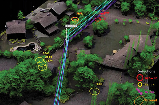
LiDAR examination of tree risk along transmission corridor
The understanding of species-specific height potentials and growth rates also have a direct consequence when planning pruning or tree removal schedules, developing integrated vegetation management (IVM) strategies, as well as understanding the consequences of extreme environmental conditions including drought, high wind, heavy snow or hurricanes, among others.
Worldwide, massive tree die-offs have been on the rise due to a variety of pathogens and insect infestations. For example, the devastating effects of the emerald ash borer on ash trees, the pine bark beetle, and Sudden Oak Death disease in the West are forcing VM programs to find new ways to rapidly assess and monitor conditions across expansive regions. Hyperspectral sensors now offer the capability of quickly analyzing and assessing conditions for wide areas from the air.
Every utility faces risks associated with dead, dying and stressed trees. These risks often require immediate action and cause the most critical concern to VM programs. New developments in advanced analytics, using aerial data, give utilities access to highly accurate and timely information for individual trees across vast areas. What used to take foot patrols months or years of sampling can now be accomplished in weeks, even days, with highly accurate, full data coverage.
Step 2: Leveraging Predictive and Prescriptive Analytics
Traditionally, VM programs relied on annual or periodic ground-based foot patrols along entire networks to identify hazards needing treatment. VM managers have to subjectively interpret the possibility of future risks in their decision making process. Varying skillsets and priorities often lead to over- or under-management of vegetation along utility corridors, resulting in the realization of unnecessary expenditures or unaddressed risks.
With the adoption of LiDAR-based aerial patrols following the 2003 Northeast blackout, utilities had a powerful new tool to catalog dangers from vegetation. Descriptive analytics derived from LiDAR quickly formed the backbone for many VM programs, describing a wide variety of information specific to vegetation, geospatial location and the relation of vegetation to infrastructure. While informative, it is a relatively simplistic approach suited to describing the current state of vegetation and answering the critical questions related to what, where and how much. Predictive analytics take this data a step further by attempting to predict vegetation status and interactions with infrastructure at some future state.
Going beyond predictive analytics there is prescriptive analytics, which offers managers actionable insights and solutions based on possible outcomes. For example, management teams can use a prescriptive model to optimize ROW treatment plans, prioritize spending based on condition- or risk-based models, incorporate IVM treatment plans, or budget for the next cycle of prescriptions and treatments.
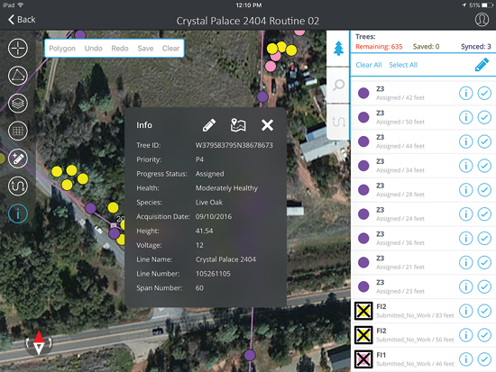
Mobile work management interface for field workers, showing tree species and
health information and offering real-time synchronization with other business processes.
Step 3: Cloud-based Access to Real-Time Analytics, Anytime, Anywhere
Historically, analytics from remote sensing data were often delivered as PDF reports, Excel spreadsheets, 2-D digital maps, or even simply the raw data. While informative, this presentation of the data created significant hurdles for VM programs that were overwhelmed by the massive quantity and unorganized nature of the incoming information. The results created frustration and confusion in the VM community and also increased exposure to substantial liability when reported vegetation risks were buried in piles of documents and left unaddressed.
With large amounts of data being converted into high-quality analytics, an organized, intuitive and integrated delivery mechanism is required to be in place for utilities to fully leverage the intrinsic advantages of the extracted information.
Modern software platforms are now being offered to organize and package analytics, while aiding in deployment of the mobile workforce and offering other integrated work management tools.
Cloud-based platforms offer stability and scalability, and enable utilities to create and manage a single source of location-based data across the entire organization. They also offer real-time access to actionable analytics to support business processes to any user, whether they’re in the office or in the field.
Because field staff often work in remote areas, software platforms are now available that enable them to work offline and automatically update work records when connectivity is reestablished. The power of syncing tree data and work histories with organized, enterprise-level databases now affords management the opportunity to provide real-time snapshots of vegetation status and a historical baseline for planning future field work. Also, tight integration with existing management systems for accounting, engineering and operations supports closed-loop processes, ensuring data stays current so vegetation management teams can direct daily duties to maximize budget and infrastructure reliability.
A Look into the Future
Across the industry, VM programs are faced with increased scrutiny related to risk exposure and operating expenses. Cycle, foot and visual patrol-based inspections are becoming increasingly difficult as operating budgets are under-funded, cut or significantly reduced over time. The traditional VM model requires new approaches as utilities accommodate additional infrastructure, alternative power sources and new customer bases.
Increasingly, autonomous robotic systems are being developed to track changes in vegetation health and growth rates, as well as changes after natural disasters for ongoing, real-time assessment, as opposed to the typical annual or periodic patrols.
Other trends in remote sensing applications point to an increasing variety of sensor types collecting more data in an even shorter period of time. This collection speed requires forward-thinking utilities and vendors to deliver solutions that can ingest the ever-increasing data load and promptly convert it to actionable information.
Continued research in remote sensing technology, sensor development, artificial intelligence, cloud-based applications, processing automations and interactive/immersive digital environments will drive the continued evolution of utility vegetation management long into the future.
About the Author
 Will Fellers is the Product Manager, Quantum Spatial Inc. Since 2006, Will has spearheaded the technical development of a comprehensive set of innovative products utilized across technical platforms at Quantum Spatial. He and his team are currently focused on state-of-the-art solutions for remote sensing applications using machine learning/artificial intelligence systems, advanced data analytics, high performance cluster computing, immersive 3-D environments and cloud-based data distribution models.