Highlights from the BRIDGE Energy Group Utility
Industry Survey on Outage and Restoration Management
Besides the obvious safety implications of having adequate vegetation clearance from power lines, power companies often face heavy regulatory pressure to ensure they maintain compliance for these clearance mandates. Major events caused by falling trees and limbs, including widespread power outages and heavy property damage, can put power companies on the hook for millions of dollars just to restore order, let alone provide their regular daily service.
Ensuring adequate vegetation clearance from power lines for years never topped the priority list for energy companies and electric utilities, but massive blackouts in recent decades (most notably the 2003 East Coast event that left tens of millions without power during a steamy August stretch) have put extra importance on a working vegetation maintenance plan. These organizations now must fully understand the regulations surrounding vegetation management and implement a safe, cost-effective process to do so.
Today, the North American Electric Reliability Corp. (NERC) requires vegetation management that prevents encroachments under all expected line positions. In short, transmission line owners must determine the minimum distance between conductors and vegetation at various positions in the right of way.
However, the process of gathering field measurements to just identify problem trees historically has been expensive and extremely time consuming. But advances in technology have made safety and compliance much easier to achieve.
Outage Notification
Recent survey results show that 81 percent of respondents have deployed smart meters for at least a portion of their customers. However, a closer look reveals that many utilities still rely on customer calls for outage notifications.
Clearance Criteria, Then and Now
Historical vegetation clearance criteria has relied on calculating minimum distance between trees and conductors. But NERC requires minimum clearance distance between vegetation and the conductor in various conditions for all expected positions in a power line’s right-of-way.
The measurer, then, must account for a variety of transmission line positions based on sag and sway as environmental and weather conditions change, but the conductor often isn’t visible from the ground because of extensive limb saturation and heavy foliage. So the conductor actually must be modeled to identify predictable but accurate line positions, and this requires a three-pronged approach:
- Ground patrols to identify potential vegetation encroachment and right-of-way clearing requirements.
- Aerial LiDAR to provide foresters with high-accuracy identification of what they can’t see on the ground as well as historical data sets for analysis.
- Area-specific field inspections to analyze vegetation at any point along the transmission line corridor and conduct specific encroachment inventories.
The LiDAR data, based on input from the ground patrol, then delivers the actual location of the vegetation that violates the criteria, and the field inspections provides the added data needed to let the modeling software do its work and pinpoint the conductor location under those specific operating conditions.
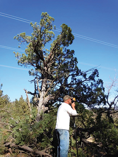
Accurate data for vegetation management professionals truly relies on a variety of technology, all of equal importance in their own right. But a professional-grade laser rangefinder used for field work delivers precise distance, height and span measurements and helps prevent repeat aerial flyovers, saving companies time and money.
 Follow-up field work is essential to locating and verifying the violation and the degree to which crews want to address it. Just like foresters often can’t see what’s above the tree line, aerial LiDAR can’t see what’s below it. But the two processes can work together in what’s called ground truthing.
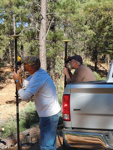
Ground truthing your clearances in vegetation management means the location, violation and terrain data revealed by aerial photography are confirmed in an actual field check – on the ground. This process used to be very cumbersome, with heavy, bulky equipment being toted around arduous terrain and moved to multiple locations to get the measurements needed.
Advances in laser design and efficiency have vastly simplified the routine. Vegetation managers can evaluate and further analyze the LiDAR data using a handheld laser rangefinder at ground level and make adjustments to trimming plans right there in the field.
Think of all the time and money a utility company could save if its crews in the field could:
- Quickly identify specific areas of concerns
- Quickly identify large areas that are not of concern, which would eliminate the costs associated with surveying those zones
- Easily determine whether specific problem areas constitute routine maintenance or should be escalated as emergency violations.
With leading laser technology and effective ground truthing processes, a vegetation manager can do all of these things by confirming or adjusting data from previous ground patrols and aerial LiDAR right from the palm of the hand.
The Total Laser Solution
The modern total vegetation management solution that utility companies rely on for vegetation management includes three components: a laser, GPS technology, and a computer. Laser rangefinders form the cornerstone of the solution, which enables field crews to navigate to the troubled locations picked up by LiDAR flyovers.
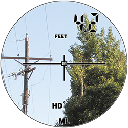
Modern laser technology can measure distance, height, azimuth, horizontal angles, and missing line values, which are essential for vegetation management. Users shoot the top of a pole or a tree and measure slope distance and the degree of inclination. With the built-in inclinometer, the laser will calculate the horizontal and vertical distances, which ultimately calculates a height value. Its integrated electronic compass technology also measures azimuth angles to a highly accurate degree.
Utilizing this compass or a horizontal angle encoder, the user takes two shots that capture the slope distance, inclination, and angle. These same values between the two shots are calculated internally, and the accurate distance and clearance measurements are delivered.
This delivers the most accurate readings for measuring clearances but also for calculating the missing line value. This important calculation determine spans between utility poles or clearances from conductors to encroaching vegetation, and lasers equipped with an electronic compass allow users to stand in a remote position and obtain accurate span values.
How It All Works Together
A power or utility company will use this total solution, in coordination with its LiDAR surveys and modeling software, to identify vegetation violations and manage transmission line corridors. Once the aerial data gets loaded and vegetation clearances are identified, field inspections using laser technology measure those clearances to make sure they meet compliance and also ensure the software models run accurately.
The need for accurate models to determine conductor and transmission line sag and sway positions is critical, and laser rangefinders allow users to take a single shot of vegetation and let the software model work. The resulting data can be transferred to work management or GIS software and can be taken right to the field. The entire right-of-way geometry, including terrain and violations inventory for LiDAR data, also can be quickly accessed in the field. So armed with information identifying problem areas, crews can easily mark trees in violation of minimum clearance standards.
Utility foresters subsequently make on-the-spot determinations of vegetation clearance violations, conduct thorough violation inventories in the field, designate violations for immediate attention, audit completed work and carry out follow-up inspections.
Advantages of using leading laser solutions with advanced compass and inclinometer technology in vegetation management, then, include:
- Faster and safer inspections for crews because of the non-contact, long-range measurements that can be made.
- Improved crew routing, reducing downtime and improving efficiency.
- Single-shot technology to make one of the most trusted tools for verifying tree-conductor conflicts also the easiest to use.
Summary
The required minimum-distance approach delivers a big picture of what power and utility companies must focus on for managing vegetation, but it’s the laser technology that delivers the details necessary to maintain vegetation upkeep.
Revolutionary laser technology allows users to flexibly determine how and where to shoot from and will deliver the ultimate ease-of-use for vegetation management professionals looking for the most accurate field inspections.
The combination of ground patrols, aerial LiDAR, and total laser solution makes for more comprehensive vegetation management, and the advanced laser technology ensures accurate data to truly help power and utility companies meet compliance standards and safely deliver service in the most cost-effective manner.
About the Author
 For over 15 years, Paul Adkins, Laser Technology’s Global Communication Marketing Manager, has been involved with laser-based product and software development for industries such as electric utilities, construction, mining, forestry and geographic information systems (GIS). Paul earned his Bachelor of Science in Business Marketing and handles many facets of Laser Technology’s marketing strategy worldwide.