
In the ever changing world of data acquisition, over the past year WIRE Services has been developing engineering and right of way management solutions for electric service utilities by utilizing high resolution imagery to create 3 dimensional data point clouds on transmission right of ways. Survey techniques are known by several names at the moment including ‘Structure from Motion’ or Photogrammetric Detection and Ranging (PhoDAR). The ability to utilize high resolution imagery to create point clouds on terrestrial objects and update information within PLS-CADD (power line design software) has started to surface as a potential new survey tool for the industry.
PhoDAR surveys have only recently become technically and commercially feasible by advances in digital imagery resolution and computing power on desktop computers. The technique transforms an array of high resolution images collected over a transmission right of way into a spatially correct dense point cloud on the natural terrain, vegetation, and man-made features.
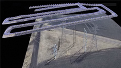
PhoDAR image pattern flown by hobby grade UAV in proof of concept studies
leading to commercial collection of imagery with fixed wing light aircraft.
The key attractiveness of PhoDAR is its low cost compared to LiDAR. Collection and processing costs of PhoDAR are approximately 1/5th or less the cost of LiDAR which makes it an attractive option for transmission lines surveyed on a recurrent schedule for regulatory and operating compliance; and also for the transmission line designer tasked with maintaining and refreshing the data within a PLS-CADD model archive.
Initial testing of images and point cloud software confirmed the extensive calibration requirements for long narrow surveys like transmission corridors. Accuracy is maintained in the PhoDAR survey if accurate known UTM coordinates are available for the program to tie into. These points are readily available on a transmission line flown with LiDAR. Known points in the LiDAR model in every transmission span are correlated to the visible tie point locations made in each image. The dense colourized point cloud is generated from the accurate tie point layer and exported to a post processing filter and point classification method. Finally, the processed data is exported to PLS-CADD for end use.
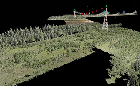
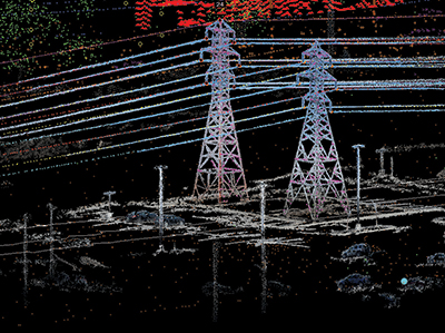
PhoDAR Point Cloud Rendering of Transmission Line Corridor with overlapping images collected by
pod-mounted cameras mounted on commercial fixed wing aircraft. The red and white crosses depict the
precise location of marker balls on the upper shield wire as determined by the image tie points made by the
PhoDAR Analyst. The PhoDAR model is tied to visual tie points made on structures, hardware, and known
objects points from LiDAR. With sufficient tie points from LiDAR and WIRE Services proprietary techniques,
the final point cloud lies in sync to the LiDAR tie points.
Over the past 9 months WIRE Services has completed multiple projects for Manitoba Hydro to test out the various applications that may be possible. Several of those will be highlighted. For Transmission Line Maintenance, the significant project was the updating of vegetation information along the twin corridor 500kv HVDC transmission lines that bring power from Northern Manitoba to southern markets, running a total of 1000 linear kilometers.
PLS-CADD Model is stripped of legacy LiDAR data on vegetation
and up to date studies on refreshed data completed.
The project involved the collection of approximately 200,000 high quality 22 MP color images, processing into point clouds, re-insertion of point clouds back into the existing PLS-CADD model, and reporting on potential vegetation interactions based on the utilities analysis criteria. Processing was completed with several desktop computers, specially modified for the computing workload.
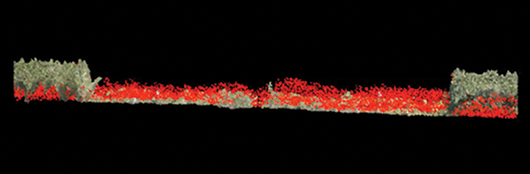
Cross section view of right of way containing fresh PhoDAR data and 5 year old LiDAR (in Red).
The differences between the two surveys depict clearing done based on an original LiDAR report
compiled on data five years old. PhoDAR can be used as a quick method to verify contractor contractual
compliance to vegetation maintenance specifications on existing line corridors, and for Greenfield projects
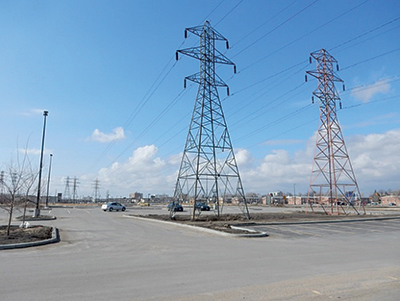
Using ground collected PhoDAR to document a new parking lot and its lighting structures to ensure
code clearances are maintained to the transmission line at all weather and operating conditions.
For the Transmission Line Designer responsible for coordinating design changes on older assets (i.e., thermal upgrades, right of way changes) it is desirable to have those changes reflected back within the PLS-CADD model.
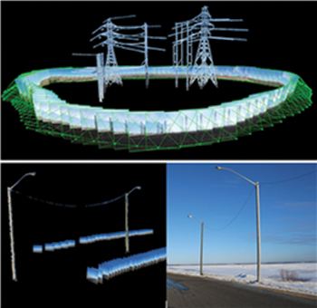
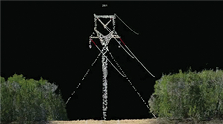
Photographs of any object of interest may be collected from
the ground to compose an accurate point cloud model.
Objects can be modeled with photography taken from air, or from the ground as long as specifications regarding image overlap, horizon positioning, and sunlight are adhered to. UTM tie points may be collected from the structure or other right of way objects. Post filtering of rendering artifacts from the bright sky background is necessary to sharpen the final point cloud.
Conclusion
The initial work completed by WIRE Services on behalf of Manitoba Hydro has provided proof of concept for multiple transmission line applications.
While this procedure has some limitations, it appears to provide another tool in the toolbox for Asset Managers, Transmission Line Designers, and Line Maintenance staff.
About the Author
 Wesley Mueller received his Civil Engineering Degree from the University of Manitoba, Canada, in 1991. He performed transmission line thermal rating studies, designed clearance solutions, and project managed the required construction activities for the utility Manitoba Hydro for 4 years from 1995-1999. He then progressed into the maintenance and asset management of the entire transmission line system in Manitoba, working in a technical role for 8 years, and then as the Department Manager for 6 years. His principle duties included developing and implementing diagnostic inspection programs, building a GIS system to improve data access and availability, and directing the asset investment strategies for the transmission line system. In 2014, Mr. Mueller undertook the role as Managing Director of WIRE Services and is responsible for all aspects of the business operations.