
Utilities today face a myriad of complex challenges – from aging infrastructure to changing regulation and increasing customer demands – but the biggest issue for many utilities is something that has traditionally been hard to predict: increasing severe weather and its impact on infrastructure. In reality, weather’s impact on a utility’s network further complicates many of the previously mentioned challenges. And the impacts of weather events can be costly from both a financial and public opinion standpoint.
According to studies from UVM, Berkeley Labs, IEEE Spectrum, and the 2013 IDC report, 44 percent of outages and 78 percent of grid disruptions are attributed to weather events. These disruptions hit the U.S. economy each year with a cost of $20- $55 billion and have increased ‘six-fold in the past 20 years.’
For utilities, being unprepared for tumultuous weather can quickly become a dire situation, as public opinion can damage a utility’s reputation after just one storm – particularly if the utility’s reaction isn’t swift and efficient. Utilities also face increased scrutiny over their power restoration times from regulators.
Aging infrastructure adds to weather and reputation challenges, combined with lagging operations and maintenance schedules, and fewer line crews. Infrastructure replacements are difficult and costly, and many utilities don’t have the resources for an infrastructure overhaul.
To combat this perfect storm of challenges, the integration of accurate weather forecasting directly into an outage management system (OMS) provides a serendipitous partnership as an innovative solution to disaster preparation and relief.
It has become common for a utility to integrate its geographic information system (GIS) – which provides a comprehensive view of network assets and conditions – with an OMS that serves as the lens through which outages are identified and monitored. By taking it a step further and integrating weather forecasting into the OMS, utilities have a whole new level of insight into not just the network, but how forecasted weather may impact asset infrastructure.
This powerful integration gives utilities the ability to plan for forecasted weather events, respond to asset damage, and recover from weather events more efficiently than ever before.
Plan for crew resources and network assets
Tracking accurate, real-time weather forecasting in relation to the network, allows a utility to better plan for crew needs – ramping up when weather events threaten and staffing lightly when the sky is clear. This agile staffing eases response planning while reducing overall costs.
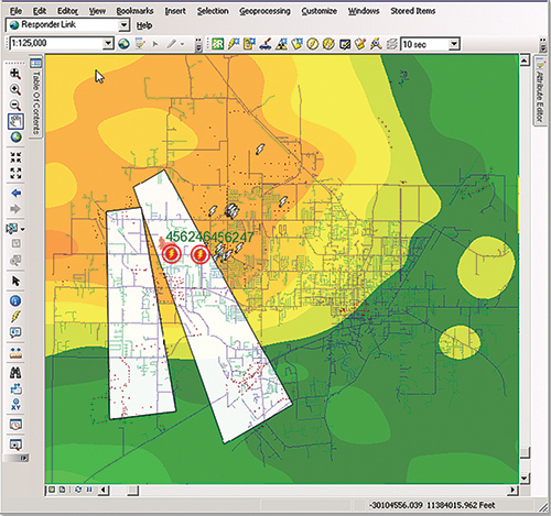
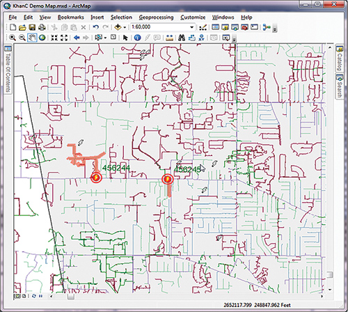
Knowing when and where a weather event is likely to strike, a utility can identify which critical assets may be in danger and prepare for shut-off and restoration needs. For example, by tracking the advance of a wildfire, a utility can determine which critical assets are in the fire path and prepare for shut-off and potential restoration. As the fire approaches buildings, service can be adjusted to avoid added risk from damaged assets, such as gas explosions. Using up-to-date, advanced network tracing tools within the combined GIS/OMS solution allows the utility to isolate shutoffs, minimizing the number of affected customers.
Armed with weather forecast data integrated with its OMS, a utility can leverage quantified outage prediction to strategically schedule and prepare crews before outages occur and request mutual assistance from neighboring utilities. These preparations mean faster restoration times as well as more efficient staffing.
A utility can monitor real-time weather data in relation to the asset infrastructure and determine when the weather-event has passed and crews can safely get to work. This balance lets crews begin restoring equipment sooner without putting them at risk.
Reduce restoration time and costs
Similarly, when a storm-related outage occurs the utility can determine with confidence where weather may still be impacting their service territory and route crews around the storm to quickly restore service and reroute supply around damaged assets to keep services online throughout restoration. The ability to precisely control and track service status, in addition to supporting restoration crews, gives utilities an important asset for communicating with customers.
This was a valuable resource during the aftermath of Hurricane Sandy, when millions of customers were left without power. Many utilities provided outage maps on their websites, using information often provided by a utility’s GIS. Some utilities even had these maps up and running before Sandy hit, allowing customers to plan and prepare for their expected days without service. On the contrary, utilities who never provided outage information suffered the customer and public relations consequences.
Informed damage assessment and infrastructure replacements
The prevalence of aging infrastructure combined with fewer line crews and a mandate to do more with less means utilities need to more efficiently identify infrastructure replacements. Historical weather data can provide a utility with the information necessary to easily determine which assets have been most frequently impacted by weather events and strategically target inspection or replacement of those assets.
Combining weather and outage data can assist utilities in improving long-term outage planning by gaining greater visibility into the asset infrastructure and its condition. For example, a utility can use historical weather data to map lightning strikes across the network and identify areas with frequent strikes. By proactively placing lightning arrestors, the utility strategically protects equipment while making the most efficient use of resources. This same lightning strike information can help a utility determine how to prioritize equipment for inspection or replacement to save time, reduce outages and ensure more accurate reporting of outage causes.
Keep the public informed and on your side
The ability to access up-to-the-minute GIS data on infrastructure, integrated with data on the disaster itself, allows utilities to be proactive in their preparations and mitigation efforts.
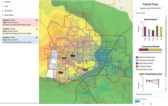
As a hurricane, fire, flood, or other weather event approaches a city – and threatens residential and commercial infrastructure – utilities are able to leverage their GIS technology to assess risk to critical infrastructure and prepare for damage related outages and take action on that information. Thus armed, the utility can better communicate with customers to help them prepare for extended outages and keep them informed on restoration progress.
Weather enabled OMS also can be a tremendous asset to the greater community. Utilities can share data from their geodatabase with first responders, fire authorities, emergency management groups and public officials who assist in planning and coordinated responses. With large-scale disasters that require public safety crews to assess a large numbers of threats, sharing accurate data on infrastructure using advanced mapping tools is a great asset to help decision makers triage problems to deploy resources.
One example of this occurred in San Diego a few years ago when fires invaded the area. The public watched as first responders arrived on the scene to protect life and property, but behind the scenes responders were able to create maps of essential infrastructure using utility information and the critical communication infrastructure. As fires approached a primary communication tower, a hub for all the main cellular carriers in the area, emergency personnel knew damage had to be prevented. If the tower went down it would have been a catastrophe, because in addition to losing cell phone service, emergency responders also would have lost their primary communications network. By having the ability to spatially assess the full range of threats and risk levels, responders were able to redeploy and prevent the loss of the tower, essential to the ongoing disaster management effort.
The combination of utility OMS with highly accurate weather forecasting opens many new doors of possibility and implementation of the two systems is easier than ever before. The most advanced systems allow the utility to integrate weather forecasting and OMS with a simple push of a button – eliminating a lot of the complicated set-up challenges that previously hindered utilities from integrating the two systems. Given that severe weather events will only become more common; having a weather-enabled outage management is an essential tool for any proactive utility.
About the Author
 Keith Hupperts is a 17-year veteran of the utility GIS market currently working as OMS product manager for Schneider Electric. As OMS product manager, Keith works to clarify market direction, and how OMS will be used to meet market needs now and in the future.
 Shylesh Muralidharan is a product manager in Schneider Electric’s global solutions business focused on building products for real-time weather data integration into energy industry applications. He has more than 13 years worldwide experience in product management and technology consulting in the energy and utilities sector. Shylesh specializes in strategy and solution design of smart grid technology projects, and generating thought leadership in the field of new energy systems and sustainability.